
City infrastructure teams are expected to manage an enormous, sprawling portfolio roads, sidewalks, streetlights, drainage systems, signage, public parks, and utility corridors often with a fraction of the staff needed to inspect it all regularly. The result is a familiar pattern: infrastructure problems get discovered reactively, usually after a citizen complaint, a safety incident, or a failure that's already expensive to fix.
AI-based monitoring is changing that model. By combining computer vision, existing camera networks, and structured asset data, municipalities can now track infrastructure condition continuously and at scale catching problems while they're still cheap to fix, rather than after they've become emergencies.
This guide covers how AI-based municipal infrastructure monitoring actually works, what it can track, and what municipalities should look for when evaluating a system.
Most municipalities still rely on a mix of scheduled inspections, citizen complaint systems (311-style hotlines or apps), and ad hoc field reports from maintenance crews. This approach has three structural weaknesses:
A pothole, a damaged guardrail, or a failing streetlight doesn't wait for the next scheduled inspection to get worse. Annual or even quarterly inspection cycles routinely miss the window where a small, cheap fix would have prevented a larger, expensive one.
Complaint-driven systems only surface problems in areas where people notice and bother to report them which skews coverage toward high-footfall areas and away from lower-traffic streets, industrial zones, and less visible infrastructure like drainage systems, where damage can go unnoticed until it causes flooding.
Field crews manually documenting asset condition, whether on paper or in a spreadsheet, can only cover a limited area per day. As cities grow and infrastructure ages, the gap between what needs inspecting and what actually gets inspected only widens and it widens faster than most municipal budgets can hire their way out of.
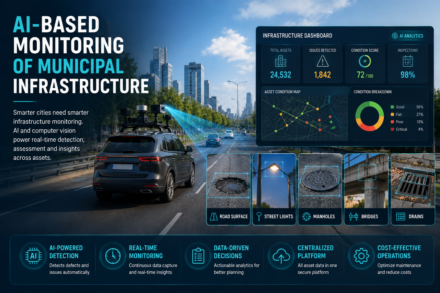
AI-based infrastructure monitoring uses computer vision and machine learning to automatically detect, classify, and track the condition of physical municipal assets from visual data video, images, or sensor feeds without requiring a person to manually inspect every asset in person.
Instead of a scheduled walkthrough or a citizen complaint being the trigger for action, the system continuously processes visual data from cameras, dashcams, or drones and flags issues as they're detected, tied to a precise location and severity level.
It applies across a wide range of municipal asset categories:
One of the biggest advantages of AI-based monitoring for municipalities is that it doesn't require building a dedicated inspection fleet from scratch. Data can be drawn from:
This flexibility matters because most cities have already invested in some camera or fleet infrastructure AI monitoring gets more value out of what's already there rather than requiring a new capital outlay.
Visual data is processed by computer-vision models trained to recognize specific municipal infrastructure conditions object-detection architectures like YOLO and Faster R-CNN are commonly used for this, given their ability to process continuous video feeds while maintaining detection accuracy across varied conditions.
For video-based capture, tracking algorithms such as SORT or DeepSORT help follow the same object or defect across multiple frames, both to avoid duplicate reporting and to increase detection confidence.
Detection isn't limited to roads the same underlying computer-vision pipeline can be trained to recognize damaged streetlights, obstructed drainage, missing signage, and degraded sidewalks, making it possible to monitor a much broader slice of municipal assets through a single platform rather than separate siloed tools for each asset type.
Every detected issue is tied to a precise location and layered onto a GIS map turning scattered detections into a spatial view of city-wide infrastructure condition. This is particularly valuable for municipal planning, where decision-makers need to see not just individual issues but patterns: a cluster of drainage blockages concentrated in one district, for example, might point to a systemic capacity issue rather than a series of unrelated incidents.
For cities building toward a broader digital twin of their infrastructure, this geotagged, continuously updated layer becomes a foundational data source a living record of asset condition rather than a static snapshot from the last inspection cycle.
Detected issues are classified by severity and fed into prioritized maintenance queues critical safety issues (a collapsed drainage cover, a non-functional traffic signal) surfaced ahead of lower-urgency items (faded lane markings, minor sidewalk cracking).
The most useful systems don't stop at generating a report they integrate with existing municipal work order and asset management systems, so a detected issue can flow directly into a maintenance team's queue without manual re-entry.
Because AI-based monitoring is inexpensive to run repeatedly compared to manual inspection, municipalities can move from periodic inspection cycles to near-continuous monitoring reprocessing footage from the same routes weekly or monthly, building a time-series record of how infrastructure condition changes and whether maintenance work is actually resolving flagged issues.
Faster response times. Issues are flagged as soon as they're captured in survey footage, rather than waiting for a citizen complaint or the next scheduled inspection often catching problems weeks or months earlier.
More equitable infrastructure coverage. Because detection isn't dependent on citizen reporting, lower-traffic streets, industrial corridors, and less visible infrastructure like drainage get the same monitoring attention as high-footfall areas.
Better budget prioritization. Severity-ranked, geotagged data lets municipal planners direct limited maintenance budgets to the highest-risk issues first, rather than working through complaints in the order they arrived.
Reduced liability exposure. Documented, timestamped condition records provide a defensible paper trail — useful when municipalities need to demonstrate they identified and responded to a hazard within a reasonable timeframe.
A foundation for smart city initiatives. Continuously updated, geotagged infrastructure data feeds directly into broader smart city and digital twin initiatives, giving planning teams a live operational picture rather than a periodically refreshed static dataset.
RoadVision AI's platform is built to ingest visual data from the sources municipalities already have dashcams on fleet vehicles, existing IP camera networks, drone surveys, and satellite imagery and run it through detection models grounded in recognized engineering standards (IRC, MoRTH, AASHTO, ASTM) alongside architectures like YOLO, Faster R-CNN, and SORT/DeepSORT tracking for continuous video analysis.
Detected issues are geotagged, mapped, and structured into condition assessments, asset inventories, and preventive maintenance recommendations that plug into existing planning workflows rather than sitting as an isolated list of flagged coordinates. This same underlying platform is running at national highway scale with NHAI, with the same core technology adaptable to city and municipal-level deployments, including Vijayawada Municipal Corporation. RoadVision AI's data infrastructure is built to ISO 27001 and SOC 2 standards, supporting the data governance requirements municipal and government deployments require.
Want to see AI-based infrastructure monitoring in action for your city?RoadVision AI's platform powers monitoring for municipal and national infrastructure alike, including deployments like Vijayawada Municipal Corporation and NHAI's national highway network. Get in touch to discuss a pilot using your existing fleet or camera infrastructure.
AI-based monitoring can track roads and pavement condition, signage and road markings, streetlights, sidewalks, drainage systems, guardrails, junction islands, and other public safety infrastructure typically through the same underlying computer-vision platform rather than separate tools per asset type.
Not necessarily. Many systems are designed to work with existing infrastructure municipal vehicle fleets fitted with dashcams, existing traffic and public safety camera networks, and periodic drone surveys rather than requiring a dedicated new camera rollout.
Well-built systems are designed to output geotagged, structured data that plugs directly into existing GIS layers and asset management or work order systems, rather than requiring manual reformatting before it's usable.
Because it can run on existing vehicle fleets and camera infrastructure rather than requiring dedicated survey equipment, and because it scales without a proportional increase in inspection staff, the cost structure tends to be more accessible than traditional inspection scale-up, even for municipalities with limited budgets. Costs vary based on network size and monitoring frequency.
Continuously updated, geotagged infrastructure condition data serves as a live operational data layer a foundational input for smart city dashboards and digital twin initiatives that require an accurate, current picture of physical infrastructure rather than a periodically refreshed static dataset.

The Autonomous Road Engineer
AI-powered road condition monitoring, asset management, & infrastructure intelligence helping agencies move from reactive maintenance to predictive road management.


.webp)
.webp)
.webp)