
A 50 km proof-of-concept for a government audit office in Gujarat using dashcam-based AI to detect and classify pavement defects against IRC 82:2023 standards, and delivering the findings through a live GIS dashboard and structured defect reports that an audit team, not a road agency, could act on.
The Office of the Principal Accountant General (Audit-II), Ahmedabad, sits under the Comptroller and Auditor General of India and is responsible for examining how public money spent on Gujarat's road infrastructure has actually been used. Its findings feed into audit paragraphs, performance audits, and reports tabled before the state legislature. Yet like most Accountant General offices, it has historically had to rely on the same executing agencies it audits state PWD, local bodies, contractors for evidence of road condition. An audit team cannot walk every kilometre it is asked to examine, and a photograph submitted by the department being audited is not independent evidence.
The audit office needed a way to generate its own objective, standards-referenced condition data fast enough to prove out on a limited network before any larger commitment, and rigorous enough that the resulting findings could support a formal audit observation. The brief was a 50 km proof-of-concept: survey a representative stretch of Gujarat road network, score it against a recognised technical standard (IRC 82:2023), and prove that the output could stand up as audit evidence rather than a vendor presentation.
Audit findings on road condition depended on data supplied by the very department being audited, with no field-collected counter-evidence available at the pace or scale an audit cycle requires.
Without a scoring methodology tied to a recognised technical code, an audit observation that a road was 'poor' was an opinion, not a finding easy for the audited department to contest.
Audit objections need a defensible location reference. Verbal or photographic submissions with no coordinate trail left objections open to the argument that the defect was misidentified or misplaced.
As a pilot, the exercise had to demonstrate value on a modest 50 km scope, at a pace and cost that could be justified internally before any recommendation to extend the methodology further.
RoadVision AI ran the proof-of-concept across Gujarat road corridors in Kutch district, including a stretch of GJ SH 88 and the Lathedi–Dumra locality road network. Two survey cycles, completed on 4 and 5 December 2025, together covered 73.7 km comfortably exceeding the 50 km proof-of-concept target with every corridor scored through the same AI pipeline so results from different survey days and road categories remained directly comparable.
The audit office and RoadVision AI agreed a representative 50 km scope across Gujarat state highway (GJ SH 88) and locality road corridors enough to exercise the full methodology without committing to a district-wide mobilisation
Survey vehicles fitted with the RoadVision AI dashcam application drove the target corridors at normal traffic speed across two cycles (4–5 Dec 2025), capturing continuous video and GPS logs. No lane closures, specialist vehicles, or road-owning-agency cooperation were required a deliberate design choice for an audit body operating independently of PWD.
Footage was processed through RoadVision AI's computer vision engine, detecting and classifying defects across categories including Potholes, Cracking, Ravelling, Rutting, Settlements, and Shoving, each at Low, Medium, or High severity. The 73.7 km surveyed yielded 18,745 classified defect instances.
Each road received a condition rating computed from its AI-detected defect profile in line with IRC 82:2023 pavement condition assessment principles, expressed on a 0–100 scale and classified into Good, Fair, or Poor bands both at the whole-road level and for every 10-metre chainage segment.
All outputs were made available through the RoadVision AI dashboard: a comprehensive road report, a defect breakdown analytics view, and a GIS map showing every inspection point with its AI-annotated photographic evidence, GPS coordinates, and defect classification built for a reviewer who was not present in the field.
The screenshots below show the RoadVision AI platform as configured for the Gujarat proof-of-concept from the survey-cycle dashboard and road register that give the audit office its topline findings, to the chainage-level GIS view an auditor could use to verify a specific defect independently.
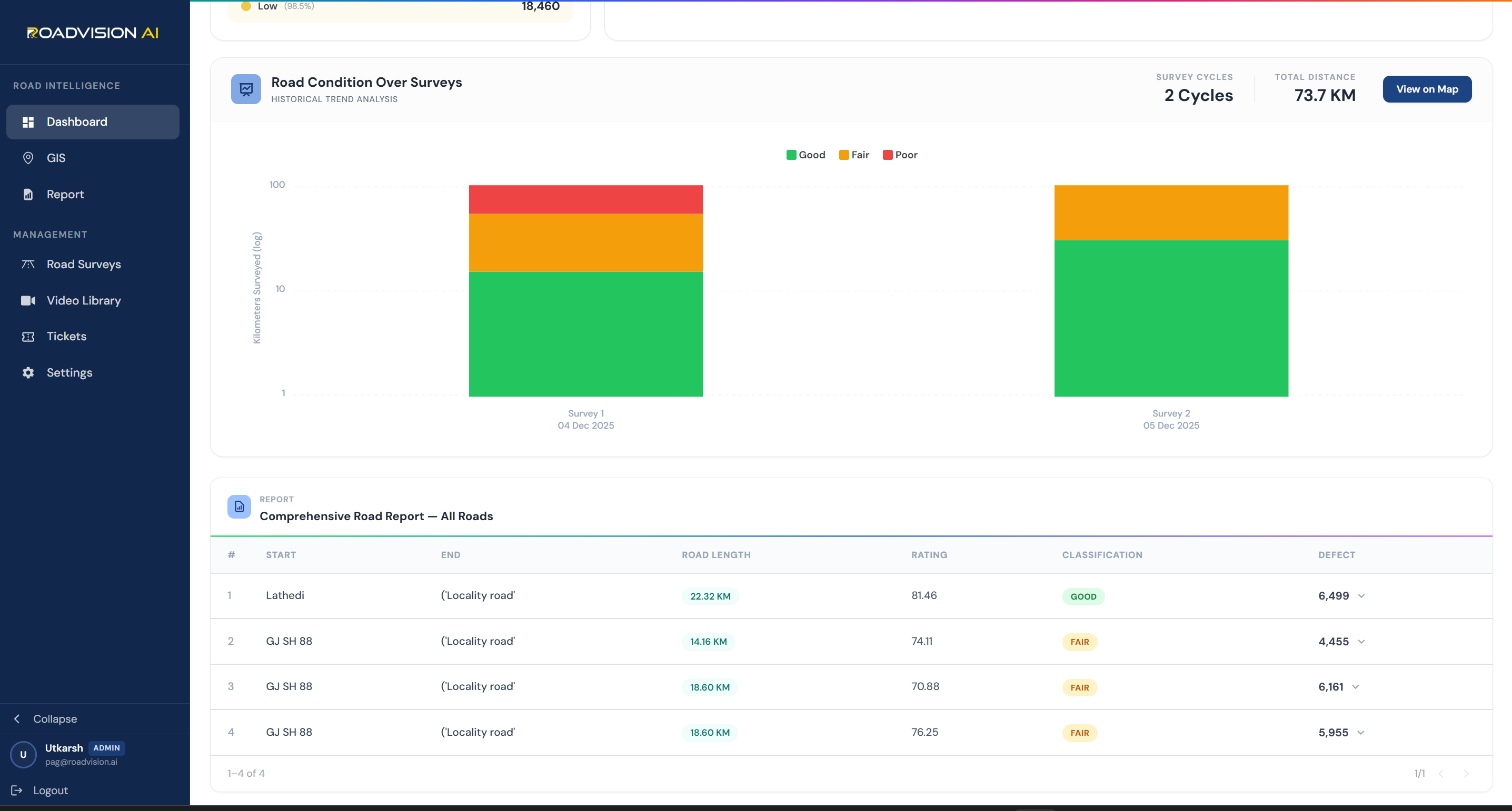

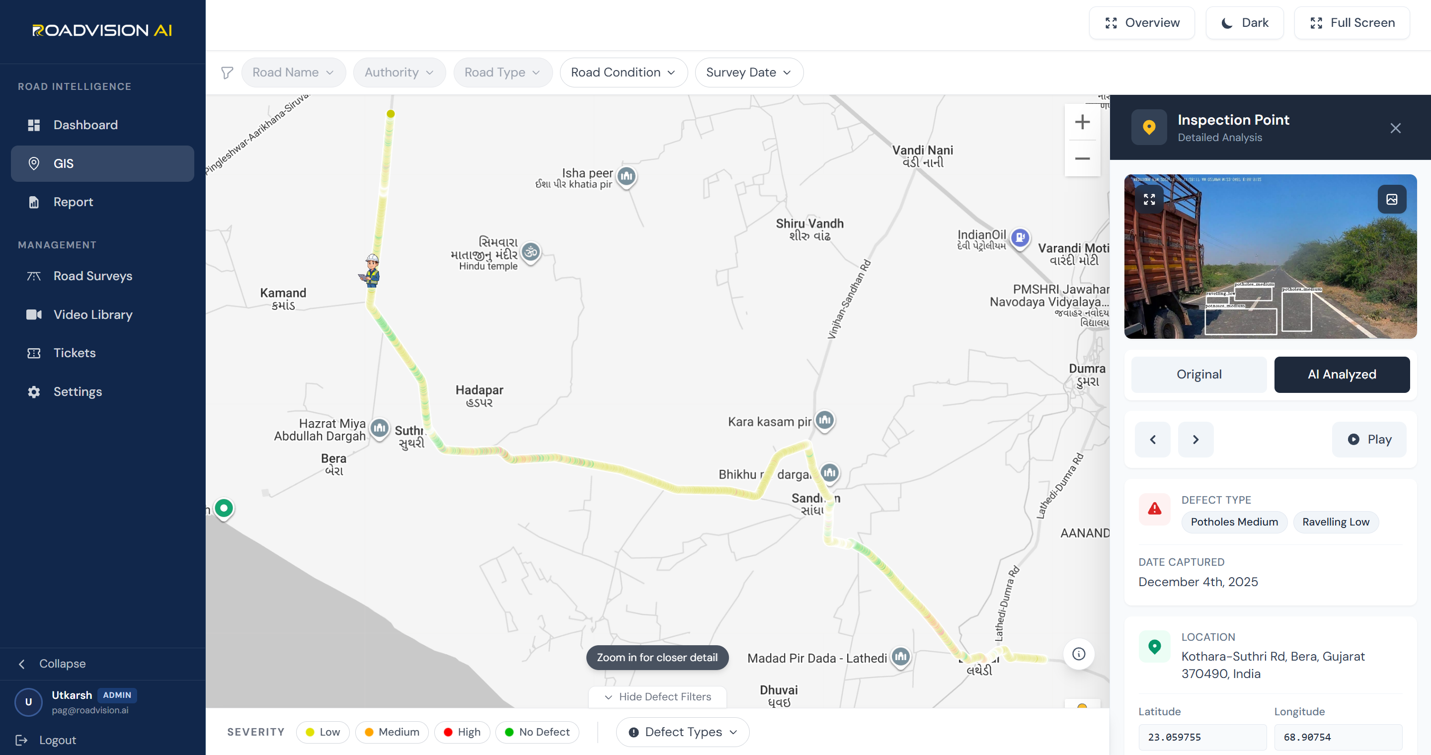
The proof-of-concept gave the audit office its first independently collected, standards-referenced condition picture of the surveyed corridors. Three of the four roads fell in the Fair band, one scored Good, and ravelling emerged as the dominant defect type by a wide margin exactly the kind of granular, corridor-specific finding that a desk audit relying on department submissions would not have surfaced.

RoadVision AI's platform delivered four structured outputs from the 73.7 km proof-of-concept each built to be usable directly in the audit workflow, from the topline dashboard a senior officer would review to the chainage-level evidence a field-verification team could act on.
The topline register for audit review
The evidence base behind the headline rating
The field-verifiable evidence layer
The standards reference that makes an audit finding defensible
The 73.7 km pilot did more than exceed its 50 km target it demonstrated that an Accountant General's office can generate its own independent, standards-referenced road condition evidence without depending on the department it is auditing.
GPS-tagged, timestamped, AI-annotated photographic evidence collected by the audit office's own survey not submitted by the department under audit for the first tim
Audit observations can now cite a specific rating against a recognised technical standard rather than a subjective description of road condition
Any audit paragraph raised from this data points to an exact 10-metre segment and coordinate pair, closing off disputes about location or defect identification.
Covering 73.7 km against a 50 km target within a two-day mobilisation shows the methodology, cost, and pace hold up beyond a pilot supporting a case for broader adoption across Gujarat's audited road network
FAQ
For Accountant General offices, PWD audit cells, and state government bodies evaluating AI-powered road condition audit methodology.
Audit findings on infrastructure spending are only as strong as the evidence behind them. Historically, an AG office assessing road quality has had to rely on data and photographs supplied by the executing department the same body whose spending is being audited. An independently collected, GPS-tagged, standards-referenced dataset lets the audit office form its own view of road condition rather than accepting a self-reported one, which materially changes what an audit paragraph can assert and how well it holds up if contested.
IRC 82:2023 sets out the technical framework for assessing pavement condition. RoadVision AI's platform computes a 0–100 condition rating for each road and each 10-metre chainage segment from the AI-detected defect profile type, count, and severity of potholes, cracking, ravelling, rutting, settlements, and shoving and classifies the result into Good, Fair, or Poor bands consistent with that framework. This converts a subjective 'this road looks poor' observation into a standards-referenced score an audit report can cite directly.
Survey vehicles use the RoadVision AI smartphone application and drive the target corridors at normal traffic speed — no lane closures, specialist vehicles, or cooperation from the road-owning department required. This was a deliberate feature for this deployment: an audit office needs to be able to collect evidence independently of the agency it is examining. The 73.7 km covered in this pilot was completed across just two survey cycles on consecutive days.
Q4. What makes the evidence produced 'audit-defensible' rather than just descriptive?
Every defect is timestamped, GPS-tagged to a precise latitude and longitude, and captured with both an original and an AI-annotated photograph showing the detected defect type and bounding box. Combined with the IRC 82:2023-aligned rating, this gives an audit paragraph three things a department response would struggle to dispute: an exact location, a dated visual record, and a standards-referenced score rather than a general assertion that a road is in poor condition.

The Autonomous Road Engineer
AI-powered road condition monitoring, asset management, & infrastructure intelligence helping agencies move from reactive maintenance to predictive road management.


.webp)
.webp)
.webp)