
Cities, counties, water districts, and public works agencies across the United States rely on Cityworks AMS (Asset Management System) as the operational core of their infrastructure asset management and maintenance programmes. Built natively on the Esri ArcGIS platform, Cityworks is the only enterprise asset management system in widespread local government use that treats GIS geometry as its primary asset identifier rather than an attribute appended to a non-spatial record. For public works departments that have invested in their ArcGIS geodatabase as the authoritative source for road network geometry, right-of-way boundaries, and infrastructure asset locations, Cityworks AMS is the natural extension turning that spatial data into a live, work-order-generating, cost-tracking, compliance-documenting operations system. For these agencies, Cityworks AMS is not going anywhere.
But one question is coming up consistently across Cityworks agencies: how do we get current, systematic road condition data into Cityworks automatically creating work orders against the right GIS features, updating road asset condition attributes on the correct ArcGIS layers, and feeding the service request and inspection workflows our teams already use without disrupting the GIS-centric asset management configuration we have built?
This guide is written specifically for GIS managers, public works directors, Cityworks administrators, and road asset managers who are already working within the Cityworks AMS and Esri ArcGIS environment and are evaluating how AI-powered road condition assessment fits into not on top of their existing GIS-native asset management workflow.
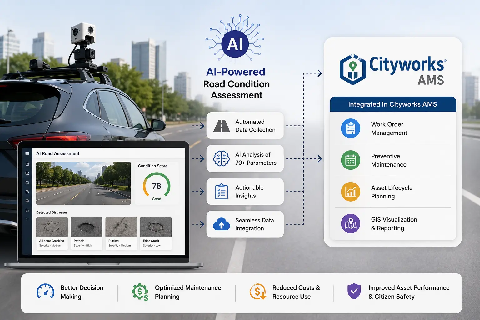
Before covering where AI fits, it is worth being precise about what Cityworks AMS actually provides for road asset management because its GIS-native architecture determines exactly how an AI condition data layer connects and where it adds immediate value.
Cityworks AMS is a GIS-centric enterprise asset management and work order system built entirely on the Esri ArcGIS platform. Unlike asset management platforms that import GIS data as a supplementary layer, Cityworks stores and manages assets directly as GIS features in an ArcGIS geodatabase road segments, signs, drainage structures, markings, and all other infrastructure assets exist first as spatially defined GIS features with geometry and location attributes, and Cityworks AMS layers work orders, inspections, and condition history on top of those features. This architecture means that every work order in Cityworks is spatially located by definition, every inspection is linked to a mappable asset, and every maintenance cost is associated with a real-world geographic location that can be visualised, queried, and reported on through ArcGIS.
In Cityworks, the asset registry is the GIS layer. Road segments, intersections, signs, pavement markings, drainage inlets, culverts, sidewalks, traffic signals, and all other public works infrastructure assets are managed as feature classes in the agency’s ArcGIS geodatabase. Cityworks reads these feature classes directly there is no separate asset import, no asset ID reconciliation between systems, and no data synchronisation lag between GIS and the asset management system. When a road segment is added to the GIS layer, it is immediately available as an asset in Cityworks AMS. When an asset’s geometry is corrected in ArcGIS, Cityworks reflects the change automatically.
Work orders in Cityworks AMS are created against specific GIS features a road segment, a sign, a drainage inlet and carry the spatial attributes of the underlying GIS feature automatically. Service requests (the Cityworks intake mechanism for public-reported issues, inspector-identified defects, and internally generated maintenance needs) are similarly created against GIS features or map locations, routing through configurable review and work order conversion workflows. For road maintenance, the ability to create a service request or work order by clicking on the road segment or defect location on a map — rather than navigating a non-spatial record hierarchy is the operational efficiency that makes Cityworks uniquely intuitive for GIS-fluent public works staff.
Cityworks AMS supports structured inspection workflows through inspection templates linked to asset types. For road pavement, an inspection template defines the condition rating fields, distress type checkboxes, severity classifications, and photo attachment requirements that an inspector completes when assessing a road segment. Completed inspections attach to the road segment’s GIS feature as a dated inspection record, building a condition history that feeds condition trend reporting and maintenance planning. The Cityworks mobile app allows field inspectors to complete inspections on a smartphone or tablet, with the asset’s GIS feature automatically identified by GPS location eliminating the need to manually navigate to the correct asset record in the field.
Cityworks AMS supports preventive maintenance (PM) templates scheduled work orders generated automatically against asset classes on defined time intervals or condition thresholds. For road infrastructure, PM templates drive routine maintenance activities: annual drainage cleaning, periodic sign inspection, marking refresh cycles, and pavement condition assessment campaigns. Condition-triggered PM where a work order is generated when a road segment’s condition attribute drops below a defined value requires condition data to be current in the GIS feature’s attribute table. When it is not, PM templates default to time-based scheduling regardless of actual asset condition.
Because Cityworks is built on ArcGIS, every work order, inspection, service request, and maintenance cost record is spatially queryable and mappable through ArcGIS tools. ArcGIS Dashboards, ArcGIS StoryMaps, and ArcGIS Online display Cityworks operational data as live map layers — enabling public works directors to present road condition heatmaps, work order density maps, and maintenance cost summaries spatially to elected officials and the public without any additional reporting development. This spatial reporting capability is one of Cityworks’ most visible operational benefits and one of the primary reasons local government agencies choose it over non-GIS-native alternatives.
Beyond roads, Cityworks AMS manages the full range of local government public works infrastructure: stormwater and drainage assets, water and sewer infrastructure, traffic signals, parks facilities, fleet, and right-of-way permits. For road agencies, this means that road condition data loaded into Cityworks exists alongside drainage condition data, permit records for ROW encroachments, and traffic signal maintenance histories — enabling integrated, multi-asset infrastructure management from a single, GIS-native platform rather than separate siloed systems for each asset class.
Cityworks acquired Lucity in 2020, expanding its platform capabilities to include fleet management, utility billing integration, and enhanced capital planning tools under a unified local government infrastructure management umbrella. For agencies using the combined Cityworks + Lucity environment, AI road condition data integrates across both platforms — feeding road asset condition into Cityworks AMS work order workflows and capital planning tools simultaneously.
Cityworks AMS manages road asset maintenance with GIS-native spatial precision and operational integration that is uniquely suited to local government public works workflows. What it does not do is generate the road condition data that its inspection records, condition-triggered PM templates, and ArcGIS-based condition reporting depend on.
The condition attributes, inspection records, and defect findings stored against road segment GIS features in Cityworks are only as current as the last time agency staff formally inspected the network and recorded the results. In practice, for most Cityworks-using municipalities and counties, this means:
The result: a GIS-native, operationally sophisticated asset management platform whose road condition layer the GIS feature attribute data and inspection records that drive condition reporting, PM template triggering, and capital planning is frequently undercurrent, inconsistently maintained, and driven by reactive complaint rather than systematic proactive assessment.
This is not a limitation of Cityworks AMS. It reflects the structural gap between what a work order and inspection management system does manage the data it is given and what a systematic road condition survey programme provides. Cityworks can only manage, plan, and report against what its road segment GIS features contain.
AI-based computer vision for road surveys addresses the road condition data generation and Cityworks entry problem directly and does so in a way that is specifically suited to Cityworks’ GIS-native architecture. The approach is operationally straightforward: a vehicle-mounted dashcam captures geo-tagged, time-stamped video of the road network as the vehicle drives at normal operating speeds. That footage is processed through AI models that detect and classify road conditions and assets automatically, returning structured, geo-referenced results formatted for direct loading into Cityworks AMS as inspection records, service requests, and GIS feature attribute updates without manual field entry, without inspection backlog, and without the staff time burden that has historically limited road condition assessment coverage and frequency for local government agencies.
No specialist survey vehicle. No contracted pavement survey crew. No manual Cityworks data entry. Any city or county vehicle already driving the road network a public works maintenance truck, a street sweeper, a code enforcement vehicle, a supervisor’s car making routine rounds becomes a continuous road condition survey platform. For agencies where available staff time is the binding constraint on Cityworks inspection record currency, this changes what is operationally achievable without additional staffing or contracted survey budget.
RoadVision AI’s models are trained on over 100 million road images from networks across South Asia, the Middle East, Southeast Asia, Europe, and Africa, covering diverse pavement types, climate conditions, road classifications, and asset configurations. For US local government agencies using Cityworks, the training data covers residential street pavement types, chip seal and microsurface treatments, asphalt overlay on concrete base, freeze-thaw damaged surfaces, and the full range of low-volume local road conditions that are the dominant pavement types in most Cityworks agency networks and that general-purpose AI models trained on highway footage frequently underperform on.
A single dashcam survey pass, processed through the RoadVision AI pipeline, returns structured condition intelligence across the following categories each mapped to the relevant Cityworks AMS and ArcGIS data structures:
Detection and classification of surface distress including potholes, longitudinal cracking, transverse cracking, alligator (fatigue) cracking, rutting, edge deterioration, patching quality, and surface ravelling. Each finding is severity-scored (Low / Medium / High / Critical) and contributes to a per-segment Pavement Condition Index (PCI) aligned to ASTM D6433 and IRC:116. An IRI-equivalent roughness value is also returned per 100-metre segment. These outputs map directly to Cityworks inspection template fields and ArcGIS road segment feature attribute columns populating the condition data that Cityworks PM templates monitor for threshold-based work order generation.
Automated detection and classification of 80+ road asset types: regulatory signage, warning signs, informational signs, road markings (centreline, edge line, stop bars, crosswalks, bike lane markings), kerb and gutter condition, ADA ramp condition, guard rails and safety barriers, drainage inlets, catch basins, culverts, lighting columns, and traffic signal infrastructure. Every detection includes GPS coordinates, asset type, condition grade, and photographic evidence structured to create or update GIS feature attributes and Cityworks asset records for each detected asset type in the agency’s ArcGIS geodatabase.
Detection of safety deficiencies including faded or missing pavement condition markings, damaged or absent safety barriers, ADA accessibility obstructions, vegetation encroachment onto the carriageway, and sight-line obstructions at intersections. Each safety finding is geo-tagged and severity-scored, providing the structured evidence needed to raise a Cityworks service request immediately against the relevant road segment or asset GIS feature creating the dated, location-referenced, photographic-evidence-backed Cityworks record that supports both operational response and statutory duty of care documentation.
Detection of visible drainage deficiencies blocked or damaged catch basin inlets, failed drainage channels, shoulder erosion, and pipe outfall obstructions alongside condition grading of culverts and stormwater drainage features. Because Cityworks AMS manages stormwater and drainage infrastructure alongside roads within the same GIS-native system, drainage condition detections map directly to stormwater asset GIS features in the Cityworks geodatabase, generating service requests and inspection records for drainage assets through the same workflow as road pavement defects.
Every detection record includes: defect or asset type, severity or condition grade, confidence score, GPS coordinates, road segment GIS feature ID (matched via spatial intersection), timestamp, and a geo-tagged photographic evidence frame structured for direct creation of Cityworks inspection records, service requests, and GIS feature attribute updates via the Cityworks REST API or direct ArcGIS geodatabase update.
Cityworks AMS’ GIS-native architecture means that integrating AI road condition data is more spatially direct than with non-GIS-native asset management platforms AI outputs carry GPS coordinates that map directly to GIS features in the agency’s geodatabase, and those GIS features are already the asset records that Cityworks work orders and inspections are created against. RoadVision AI outputs are structured to exploit this spatial alignment, enabling AI-generated condition data to enter the Cityworks AMS environment as spatially accurate, GIS-feature-referenced native Cityworks objects.
This is the integration point that directly updates the road condition layer in Cityworks and activates PM template threshold triggers. RoadVision AI delivers AI-derived condition scores — PCI, IRI, individual distress type presence, and severity ratings — as Cityworks inspection records created against the road segment GIS features identified by spatial intersection with the AI survey GPS coordinates, via the Cityworks REST API (WorkOrder/Inspection endpoints). Inspection records are created with the correct inspection template, condition field values, detection date, inspector reference (AI Survey), and attached photographic evidence. Once created, these inspection records update the condition attribute on the associated road segment GIS feature immediately refreshing Cityworks PM template evaluation and ArcGIS condition map layers.
For defects detected above a configured severity threshold Critical or High severity potholes, damaged barriers, absent safety markings, blocked drainage inlets RoadVision AI delivers Cityworks service requests created against the relevant road segment or asset GIS feature via the Cityworks service request API. Each service request includes: GIS feature reference (road segment or point asset), request type, description, priority, GPS coordinates, detection timestamp, and attached photographic evidence. Service requests appear in the Cityworks queue with the same structure as manually created requests or 311-originated requests, routing through the existing review and work order conversion workflow without any configuration change.
Because Cityworks stores assets as ArcGIS GIS features, AI condition data can also update the condition attribute fields directly on road segment and asset feature classes in the ArcGIS geodatabase via ArcGIS Feature Service REST API or direct geodatabase connection. This approach updates the GIS layer simultaneously with the Cityworks inspection record, ensuring that ArcGIS Dashboards, condition heatmaps, and any ArcGIS Online map services built from the road segment feature class reflect current AI-measured condition immediately following each survey cycle, without waiting for Cityworks inspection record processing to propagate to the GIS layer.
Cityworks PM templates configured with condition-based triggers monitor the condition attribute field on road segment GIS features and generate work orders when the value crosses a defined threshold. When RoadVision AI updates both the Cityworks inspection record and the GIS feature attribute with a new AI-measured PCI value, Cityworks evaluates the updated condition against PM template thresholds automatically generating planned preventive maintenance work orders for road segments where the AI-measured condition has dropped below the configured intervention point. For agencies that have configured condition-based PM templates but rarely seen them trigger due to infrequent manual inspection, AI survey integration is the change that makes condition-based preventive maintenance a live operational reality rather than an aspirational configuration.
Because AI condition data updates the underlying ArcGIS GIS feature class attributes the same data source that ArcGIS Dashboards, ArcGIS Online web maps, and ArcGIS StoryMaps consume every road condition visualisation built on top of Cityworks’ GIS data is automatically refreshed following each AI survey cycle. The road condition heatmap presented to a city council reflects current AI-measured condition from this survey cycle, not values from an inspection conducted one to three years ago. The “worst streets” list generated from Cityworks for capital programme presentations is derived from current data. The public-facing road condition portal, if one exists, reflects what the road network actually looks like today.
RoadVision AI connects to Cityworks AMS through the Cityworks REST API, which exposes endpoints for service request creation, work order creation, inspection record creation, and asset attribute retrieval. For agencies that have implemented Cityworks PLL (Permits, Licenses, and Land) alongside AMS, AI-detected ROW encroachments can generate permit review service requests through the same API. For agencies using ArcGIS Enterprise or ArcGIS Online, AI condition data is delivered as a feature service update to road segment and asset feature classes keeping GIS and Cityworks in sync from the same AI data delivery.
Once integrated, AI survey data participates in every downstream Cityworks AMS and ArcGIS workflow the agency already runs: PM template condition threshold evaluation, service request queue management, work order generation and crew assignment, inspection record compliance audit trail, ArcGIS Dashboard condition reporting, capital programme prioritisation, and council and public communication maps. Public works staff work in the same Cityworks and ArcGIS environment they have always used the difference is that the road segment GIS feature attributes and Cityworks inspection records are current, comprehensive, and consistently populated after every survey cycle.
What does not change: The Cityworks AMS platform. The ArcGIS geodatabase structure. The road segment and asset GIS feature classes. The work order and service request types. The PM template configuration and condition thresholds. The inspection template fields. The ArcGIS Dashboard and web map configuration. The Cityworks mobile app workflow.
What changes: The frequency, coverage, and consistency of the road condition data entering the Cityworks inspection records and GIS feature attribute fields that drive every condition-dependent function in the platform.
Condition-based PM templates fire on current field conditions. Cityworks PM templates configured with condition thresholds evaluate the condition attribute on road segment GIS features. With AI surveys updating those attributes on a regular cycle, PM templates finally fire as designed generating preventive maintenance work orders when road condition genuinely crosses the intervention threshold, not when a manual inspection happens to be scheduled. Proactive, condition-driven maintenance replaces a significant share of reactive complaint-driven work orders.
ArcGIS condition heatmaps become genuinely current. The road condition maps that public works directors present to city councils and post on public-facing portals are generated from Cityworks inspection data stored as GIS feature attributes. With AI surveys refreshing those attributes regularly, condition heatmaps reflect the current state of the road network rather than a snapshot from the most recent inspection cycle. Council presentations and capital programme justifications are grounded in current data not in values that were collected before the last election.
Service request queues shift from reactive to systematic. When AI road surveys detect and severity-score defects across the full road network and create Cityworks service requests for high-priority findings, the service request queue reflects the actual condition of the network rather than the geographic and socioeconomic biases of who calls 311. Maintenance resources are deployed based on systematic condition evidence rather than on the persistence and frequency of complaint activity from specific neighbourhoods or council districts.
Full network coverage becomes achievable for every survey cycle. Traditional inspection programmes prioritise arterials and known problem areas because manual inspection staff time is finite. AI processing of city vehicle dashcam footage covers every road segment GIS feature in the Cityworks geodatabase on every survey pass including cul-de-sacs, alleys, subdivision streets, and low-volume roads that have not received a formal Cityworks inspection in years. Every road segment in the GIS layer receives a current condition record.
Duty of care documentation becomes systematic and complete. Every AI road detection that creates a Cityworks service request or inspection record generates a dated, geo-tagged, photographic-evidence-backed record in the system. The Cityworks audit trail defect detected, service request created, work order raised, crew dispatched, maintenance completed is complete and consistent across the full network, not just for roads that generated a public complaint. For agencies with statutory road inspection and response obligations, this systematic documentation significantly reduces the compliance and liability exposure created by gaps in manual inspection coverage.
Multi-asset stormwater and ROW data becomes current alongside road condition. Because Cityworks manages drainage, stormwater, and ROW assets in the same GIS-native environment as road pavement, AI detection of drainage deficiencies and ROW encroachments updates the Cityworks records for those asset classes in the same survey pass refreshing the full public works asset picture simultaneously rather than requiring separate survey campaigns for each asset type.
The evaluation path is designed to be practical for public works GIS and Cityworks teams:
For Cityworks AMS agencies, the core question is straightforward: can we get current, systematic road condition data into our road segment GIS features and Cityworks inspection records frequently enough and at low enough cost to make condition-based PM templates operationally active — and can we do it without manual field entry overhead that our staffing levels cannot sustain? That is the specific problem this integration is designed to solve.
RoadVision AI provides AI-powered road survey intelligence to public works agencies, departments of transportation, road authorities, and infrastructure operators globally. Our computer vision models are trained on 100M+ road images across diverse pavement types, climate environments, and road classifications, including the local street pavement types common in US municipal and county road networks. To request technical documentation, a sample Cityworks data package, or a GIS feature integration demonstration, contact us at contact@roadvision.ai or visit roadvision.ai.
What camera hardware is required?
Any GPS-enabled dashcam producing standard MP4 or MOV video at 1080p or above. No proprietary hardware, no calibration rig, and no vehicle modifications beyond mounting the camera. Any city or county vehicle already operating on the road network — a public works truck, a code enforcement car, a street sweeper serves as a survey platform.
Do we need to train or configure the AI models?
No. The models are pre-trained and deployed, including coverage of local street pavement types common in US municipal networks: asphalt, chip seal, microsurface, concrete, and composite surfaces across freeze-thaw and warm-climate environments. No model training, annotation project, or configuration work is required on the agency side.
How does AI condition data connect to our road segment GIS features in Cityworks?
AI detection records carry GPS coordinates that are spatially intersected with the agency’s road segment GIS feature class to identify the correct Cityworks asset for each detection. RoadVision AI delivers condition data as Cityworks inspection records created via the Cityworks REST API, with the road segment GIS feature ID automatically matched by spatial intersection. Simultaneously, the corresponding ArcGIS road segment feature attribute fields are updated via the ArcGIS Feature Service REST API keeping Cityworks and the ArcGIS GIS layer in sync from the same delivery.
Can AI detections automatically create service requests in Cityworks?
Yes. Defects detected above a configured severity threshold are delivered as Cityworks service requests created via the Cityworks REST API against the relevant road segment GIS feature. Each service request includes the GIS feature reference, request type, description, priority, GPS coordinates, detection timestamp, and attached photographic evidence. Service requests appear in the Cityworks queue for planner review and work order conversion identical in structure to manually created or 311-sourced service requests.
How does this activate our Cityworks PM template condition thresholds?
Cityworks PM templates with condition-based triggers monitor the condition attribute value on road segment GIS features. When RoadVision AI updates the inspection record and GIS feature attribute with a new AI-measured PCI, Cityworks evaluates the updated value against configured PM thresholds automatically generating planned work orders for segments where the condition has crossed the intervention point. For agencies where condition-based PM templates are configured but rarely trigger due to infrequent manual inspection, this is the integration that makes them operationally active.
Will AI condition data update our ArcGIS Dashboards and web maps automatically?
Yes. Because AI condition data updates the attribute fields on the road segment GIS feature class — the same data source that ArcGIS Dashboards, ArcGIS Online web maps, and StoryMaps consume — all condition visualisations built from that feature class are automatically refreshed. Road condition heatmaps, worst-streets lists, and work order density maps reflect current AI-measured data immediately following each survey cycle update.
Does this work for drainage and stormwater assets in Cityworks, not just road pavement?
Yes. AI detection of drainage deficiencies — blocked catch basin inlets, failed culverts, shoulder erosion at drainage structures maps to stormwater and drainage GIS features in the Cityworks geodatabase, generating service requests and inspection records for drainage assets through the same Cityworks API workflow as road pavement detections. Agencies managing stormwater alongside roads in Cityworks receive a multi-asset condition update from a single survey pass.
Can AI survey data support our HSIP or CDBG grant applications documented through Cityworks?
Yes. AI safety deficiency detections faded markings, damaged barriers, intersection sight-line obstructions create structured Cityworks service request and inspection records with photographic evidence that support local road safety plan development and HSIP project identification. AI-derived PCI data documented in Cityworks inspection records supports CDBG pavement condition requirements. Both use the Cityworks audit trail as the documentation basis for grant applications.

The Autonomous Road Engineer
AI-powered road condition monitoring, asset management, & infrastructure intelligence helping agencies move from reactive maintenance to predictive road management.


.webp)
.webp)
.webp)