
A city-wide deployment of RoadVision AI across Khammam 264.9 km of municipal roads surveyed and analysed across five survey cycles, identifying 93,545 defects across pavement, roadside assets, and road safety features via dashcam-based AI, and delivered through a live GIS dashboard with PCI-based road classification and a phased remediation roadmap.
Khammam Municipal Corporation manages a road network spanning every ward of the city arterial roads, colony streets, and connecting links that residents depend on daily. Like most Urban Local Bodies in India, Khammam's engineering wing faced a challenge that had nothing to do with lack of effort and everything to do with lack of measurement: pavement condition, roadside asset health, and road safety compliance were each tracked, if at all, through separate field registers, ward-level complaints, and periodic manual checks that could never keep pace with a 250+ km network.
Potholes and cracking were visible and got reported. Missing drain cover slabs, faded pavement markings, and encroachment on carriageway width were not until they caused an accident, a flooded street, or a monsoon-season failure. The Corporation needed a single, city-wide baseline that covered not just pavement condition but the full range of roadside infrastructure and safety assets, scored against an objective methodology, and translated into a prioritised action plan its limited maintenance budget could actually execute.
With road data scattered across ward offices and paper registers, there was no way to compare corridor condition, rank maintenance priority, or present a defensible city-wide maintenance budget.
Damaged kerbs, missing drain covers, and faded markings went unrecorded until they caused a monsoon flooding incident, a road safety complaint, or vehicle damage never anticipated, only reacted to
Every allocation decision between wards was effectively subjective, with no standardised condition index to justify why one road was funded before another.
Without a persistent digital baseline, each field visit started from scratch deterioration rates, defect recurrence, and the effectiveness of past repairs were all unmeasured
RoadVision AI deployed its AI road condition platform across Khammam Municipal Corporation's full road network conducting mobile data collection across 216 roads spanning every ward, with five survey cycles run between January and February 2026. The deployment covered roads from short colony connectors to multi-kilometre arterial corridors, with every road assessed through the same AI pipeline across three distinct domains: Roadway Surface, Asset Management, and Road Safety.
Khammam Municipal Corporation and RoadVision AI agreed a full-network scope covering 264.9 km of city roads across all wards arterials, colony roads, and connecting streets assessed under a single, comparable methodology.
Survey vehicles fitted with the RoadVision AI smartphone application drove the city network at normal traffic speed across five cycles run through January and February 2026, capturing continuous video and GPS logs. No lane closures or specialist equipment were needed a scale of coverage a manual survey team could not match in the same time frame.
Captured footage was processed through RoadVision AI's computer vision engine across three domains Roadway Surface (potholes, rutting, cracking, shoulder condition), Asset Management (kerbs, drains, crash barriers, signage), and Road Safety (markings, work-zone safety, encroachment) —yielding 93,545 classified defect instances at Low, Medium, or High severity.
Each of the 216 surveyed roads received a Pavement Condition Index (PCI) score computed from its AI-detected defect profile, expressed on a 0–100 scale and classified into Good, Fair, or Poor bands giving every road in the city a directly comparable, standards-referenced rating.
All outputs were integrated into the RoadVision AI live platform a paginated, searchable road register (216 roads across 44 pages), a multi-domain defect dashboard, a GIS map with AI-annotated evidence, and a phased remediation roadmap sequencing interventions by ward, severity, and budget impact
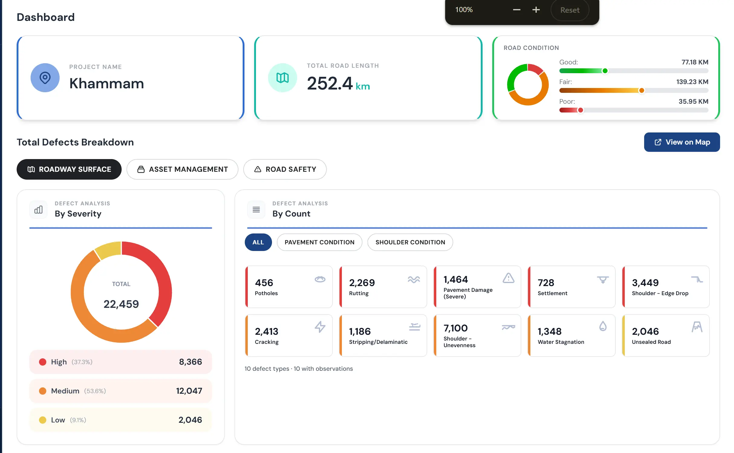
The screenshots below show the RoadVision AI platform as deployed for Khammam from the survey-cycle trend and city-wide road register, to the domain-by-domain defect dashboards covering pavement, roadside assets, and road safety. This is the interface Khammam Municipal Corporation's engineers and administrators use to move from a paper register to a live, always-current city road database.

An excerpt of five roads from Khammam's 216-road register,illustrating the level of per-road detail available across the full city network.

The city-wide survey gave Khammam Municipal Corporation its first objective, data-driven picture of its complete road network not just pavement condition, but the roadside assets and safety features that determine how liveable and safe those roads actually are. The findings confirmed that road safety and asset-related defects, not potholes, represent the largest share of the Corporation's maintenance backlog.
RoadVision AI's platform delivered five structured outputs from the Khammam city-wide survey each serving a different user, from the engineer reviewing a single ward to the administrator planning next year's maintenance budget
The operational command view for city engineers and administrators
● Paginated,searchable register of all 216 surveyed roads (44 pages) with PCI rating,condition classification, and survey history
● Colour-coded condition flags (green Good, amber Fair, red Poor) enabling ward-by-ward triageat a glance
● One-click access to full road report and annotated video evidence from any road in the register
Live update as re-surveys are completed the register always reflects current, not historical, condition
The analytical layer spanning pavement, infrastructure, and safety
The field-verifiable evidence layer
The standards-referenced scoring that makes budgets defensible
The plan that turns 93,545 defects into an executable programme
Khammam's deployment demonstrates what AI-powered road condition intelligence delivers when applied not to a single corridor but to an entire municipal network across three infrastructure domains at once. The outcomes extend well beyond the 264.9 km surveyed.
216 roads, three defect domains, and 93,545 classified findings now live in a single searchable register replacing ward-level paper records with one current source of truth
10,498 missing drain cover slabs were surfaced before the next monsoon season, not after a flooding incident giving the Corporation time to act rather than react.
Council can now direct maintenance funding to the roads and asset categories with the greatest measured need, rather than the loudest ward complaint.
Five completed survey cycles establish the measurement rhythm Khammam can repeat going forward, tracking whether the remediation roadmap is actually closing the defect count over time.
RoadVision AI surveyed 264.9 km of Khammam's city road network across 216 individual roads, spanning every ward, over five survey cycles run between January and February 2026. The survey covered arterial roads, colony streets, and connecting links, assessing each one across three domains Roadway Surface, Asset Management, and Road Safety rather than pavement condition alone.
The Pavement Condition Index (PCI) is a 0–100 standards-referenced score used internationally to express pavement condition in a comparable, objective way. RoadVision AI computes each road's PCI from its AI-detected defect profile the type, count, and severity of surface defects such as potholes, cracking, rutting, and shoulder unevenness and classifies the result into Good, Fair, or Poor bands. This turns a field impression of 'this road needs work' into a specific, comparable number every road in the register carries.
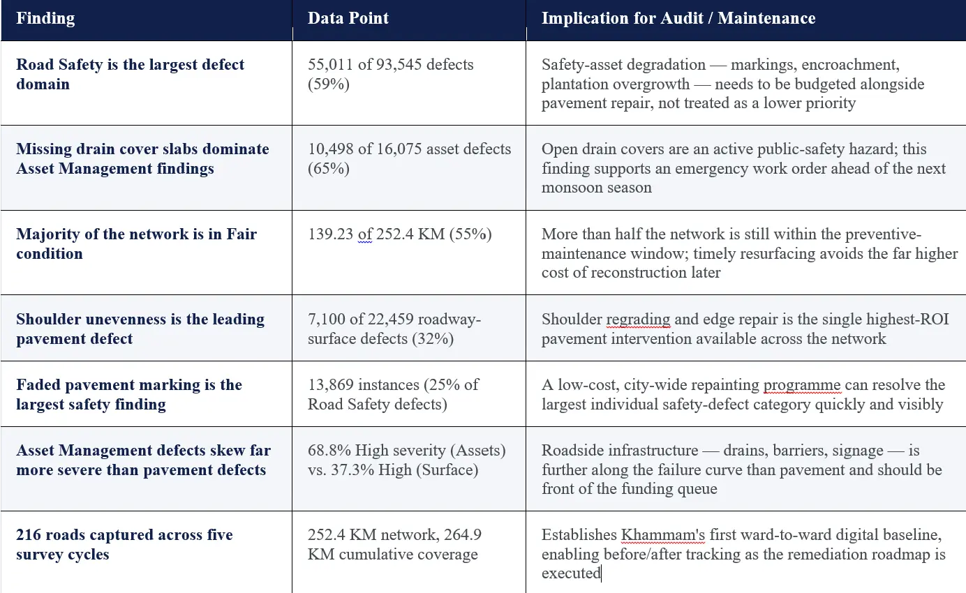
A road's condition is not just its pavement. Missing drain covers, damaged crash barriers, faded lane markings, and encroaching plantation growth all affect safety and liveability but are invisible to a pavement-only survey. Khammam's data shows why this matters: Road Safety defects (55,011) outnumbered pavement defects (22,459) by more than 2 to 1, and Asset Management defects carried the highest severity share (68.8% High) of any domain. Treating these as one combined survey, rather than three separate exercises, gives the Corporation a single prioritisation view across all of them.
The roadmap sequences Khammam's 93,545 defects into an executable work programme grouped by ward, ranked by severity and safety risk, and sized to realistic budget cycles rather than presented as one unfunded mega-project. High-risk items such as the 10,498 missing drain cover slabs are positioned for early-phase action, while lower-severity, high-volume items such as faded pavement marking are grouped into cost-efficient batch programmes. It is designed to be taken to Council for phase-by-phase budget approval.
The Asset Management survey found 10,498 missing drain cover slabs 65% of all asset defects and the single largest finding across the entire survey. Open drain covers are an immediate safety hazard, particularly during monsoon flooding when water can obscure them entirely. Because each one is GPS-tagged and photographed, the Corporation can generate ward-specific replacement work orders directly from the dataset, rather than waiting for individual complaints or, worse, an injury to surface the problem.

The Autonomous Road Engineer
AI-powered road condition monitoring, asset management, & infrastructure intelligence helping agencies move from reactive maintenance to predictive road management.


.webp)
.webp)
.webp)