
A pilot survey using dashcam-based AI across primary Bangalore road stretches capturing GPS-tagged, chainage-level defect, asset, and geometric road-width data (carriageway, footpath, median, kerbstone) at 100-metre intervals, benchmarked against 50+ global standards across 68 parameters. Delivered via per-road PDF/Excel reports, GIS/KML outputs, a video library, and an interactive dashboard validating the methodology ahead of a full-scale 2,800 km programme across Bangalore.
Arcadis Design and Consultancy was scoping a citywide road asset management programme for Bangalore a 2,800 km undertaking spanning arterial corridors, ward roads, and connecting streets across the city. Before committing engineering resources and client budget to a programme of that scale, Arcadis needed proof that an AI-based survey methodology could deliver data precise and comprehensive enough to support actual design decisions, not just a maintenance triage list.
Consultancy-grade engineering work has a higher bar than a typical condition survey. Design teams need geometric measurements carriageway width, footpath width, median width, kerbstone dimensions not just defect flags. Findings need to be benchmarked against the specific mix of international and national codes a given project references, not one fixed standard. And the resulting data needs to flow directly into the tools Arcadis's design, GIS, and reporting teams already use. The brief was a pilot: survey a primary Bangalore corridor to full design-data depth, and prove the methodology before it is applied at 2,800 km scale.
Consultancy projects reference a mix of international and national engineering codes. A survey built around a single standard could not satisfy the range of design requirements Arcadis's programme would need to meet.
Carriageway, footpath, median, and kerbstone width are traditionally measured by hand at intervals far too sparse and far too slow to cover 2,800 km within any realistic programme timeline or budget.
Committing engineering resources and client budget to a 2,800 km programme on an unproven method carried real delivery risk the pilot needed to demonstrate throughput, accuracy, and deliverable quality first.
Design teams work in PDF and Excel, GIS teams work in spatial formats, and QA needs visual evidence a single dashboard export was not enough to slot into Arcadis's existing processes
RoadVision AI ran the pilot across a primary Bangalore corridor around Okali puram and Magadi Road, surveying 12 dual-carriageway stretches to full design-data depth defects, roadside assets, safety findings, and geometric road-width measurements together, at a chainage resolution fine enough to support engineering decisions rather than just maintenance triage.
Arcadis and RoadVision AI agreed a representative primary corridor the Okalipuram–Magadi Road stretch covering 12 dual-carriageway segments (LHS and RHS surveyed independently) as a proving ground before any city-wide commitment.
Survey vehicles fitted with the RoadVision AI application drove each carriageway at normal traffic speed, with day and night capture supported, logging continuous video and GPS position at 100-metre chainage intervals the resolution needed for stretch-by-stretch design work, not just road-level averages.
Footage was processed through RoadVision AI's computer vision engine across Roadway Surface, Asset Management, and Road Safety domains, while carriageway, footpath, median, and kerbstone widths were extracted at every chainage point combining condition data with the geometric measurements design teams require.
Every finding was benchmarked against a library of more than 50 global and national engineering standards across 68 distinct parameters in a single survey pass giving Arcadis one dataset that can be referenced against whichever code mix a given design task requires
Outputs were packaged into the formats Arcadis's teams already work in: per-road PDF and Excel reports, GIS/KML spatial files, a chainage-linked video library, and a live interactive dashboard validating that the methodology's deliverables, not just its data, would fit a 2,800 km programme.
The screenshots below show the RoadVision AI platform as deployed for the Bangalore pilot from the dashboard summarising the corridor's condition, to the domain-by-domain reporting views Arcadis's engineering teams used to review pavement, asset, and safety findings ahead of the full 2,800 km programme.

An excerpt of four carriageway segments from the 12-segment pilot register, illustrating the per-carriageway (LHS/RHS) reporting granularity used across the corridor.
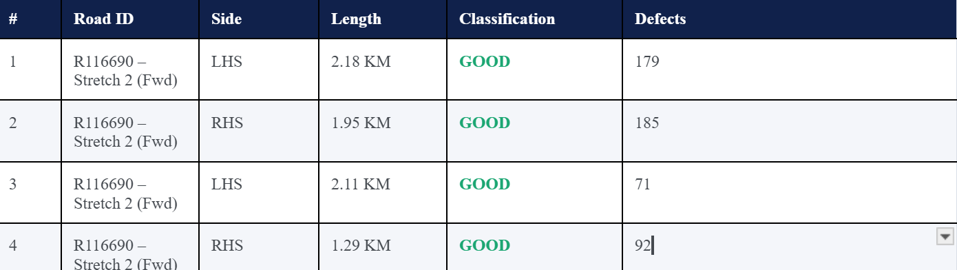
The pilot corridor gave Arcadis its first design-grade dataset combining condition, asset, and geometric data in a single AI survey pass. Beyond validating throughput and deliverable quality, the findings themselves surfaced patterns relevant to how the full programme should be scoped and sequenced.

RoadVision AI's platform delivered five structured outputs from the Bangalore pilot each matched to a different Arcadis workflow, from the live dashboard used in review meetings to the geometric dataset design engineers work from directly.
The review and QA interface
Design-ready documentation for direct reuse
Spatial data for design and planning teams
The QA and verification layer
The design-stage data manual surveys could not deliver at this scale
The pilot corridor was never the point in itself it was the proof Arcadis needed before scoping a citywide programme. Every outcome below speaks directly to whether the methodology could be trusted at 2,800 km, not just 10.7.
Throughput, accuracy, and deliverable quality were proven on a real corridor de-risking the decision to commit engineering resources to the full citywide programme.
Geometric width measurements alongside condition and asset data give Arcadis's design engineers what they actually need to specify interventions, not just flag problems.
PDF, Excel, GIS/KML, and video outputs slot directly into Arcadis's design, spatial, and QA processes no new tooling required to adopt the methodology at scale
A single AI pass benchmarks findings against the full range of codes a consultancy programme may need to reference eliminating the need for separate surveys per standard.
FAQ
For engineering consultancies, urban planning teams, and civic bodies evaluating AI-based road survey methodology ahead of a large-scale programme.
Arcadis was scoping a 2,800 km citywide road asset management programme for Bangalore and needed to validate an AI-based survey methodology before committing resources at that scale. The pilot covered a primary corridor around Okalipuram and Magadi Road 12 dual-carriageway segments surveyed to full design-data depth: defects, roadside assets, road safety findings, and geometric road-width measurements, benchmarked against a broad set of global engineering standards.
RoadVision AI's platform benchmarks survey findings against a library of more than 50 international and national engineering standards covering pavement condition, geometric design, and roadside asset criteria across 68 distinct measurable parameters. This allows a single survey pass to serve design requirements that reference different codes depending on the specific project, rather than requiring a separate survey for each standard a consultancy might need to satisfy.
Defect data alone tells you where a road has failed; geometric data tells you what you have to design with. Carriageway, footpath, median, and kerbstone width are foundational inputs for widening, resurfacing, and streetscape design decisions. Capturing them through the same AI survey pass — rather than a separate manual measurement exercise — is what makes the methodology viable at 2,800 km scale, where manual geometric surveys would be prohibitively slow and expensive.
Rather than a single average rating for an entire road, every 100 metres of surveyed carriageway receives its own defect, asset, and geometric readout. This is the resolution a design engineer needs to specify where an intervention starts and ends, as opposed to a maintenance team that might work from a whole-road average. The pilot's 12 segments were each captured at this resolution, independently for the left-hand and right-hand carriageway.

The Autonomous Road Engineer
AI-powered road condition monitoring, asset management, & infrastructure intelligence helping agencies move from reactive maintenance to predictive road management.


.webp)
.webp)
.webp)