
A 60 km AI-powered road safety survey of the Radhanpur–Chanasma Road in Gujarat using vehicle-mounted dashcam surveys and AI-based analysis to identify and geo-tag road safety concerns, classify risk as High, Medium, or Low, and map every finding to the relevant IRC provision, including dedicated compliance assessments for road signage (IRC 67) and road markings (IRC 35). Delivered through a GIS dashboard giving the road authority location-specific, actionable insight to support safety planning
The Radhanpur–Chanasma Road is a district-connecting corridor in Gujarat, linking a string of villages Radhanpur, Amirpura, Gochanad, Daudpur, Baspa, Varana, Jalalabad, and Sami across roughly 60 km. Like most rural and district-level roads in India, it carries real traffic risk but rarely receives the kind of formal, code-referenced safety review that busier state highways get. A traditional Road Safety Audit, run by a multi-disciplinary expert panel physically walking or driving the corridor, is thorough but slow, expensive, and infrequent leaving long gaps in which damaged safety furniture, overgrown shoulders, and non-compliant signage go unreported.
The road-owning authority needed a way to run a safety-focused assessment across the full 60 km stretch that did more than flag potholes one that could identify safety-critical issues specifically, classify them by risk severity, and tie every finding back to the IRC provision it relates to, so the results could feed directly into a maintenance and budget decision rather than sit as a general condition report.
A traditional expert-panel RSA is resource-intensive to mobilise, meaning most district-connecting roads like this one go long stretches without any formal, structured safety review.
Safety observations are often recorded informally, without being tied to the IRC clause they relate to making it hard for a maintenance engineer to know exactly what standard a fix needs to meet.
Damaged crash barriers, especially near water crossings, carry severe run-off-road risk but have no continuous monitoring mechanism outside a scheduled audit cycle.
IRC 67 (signage) and IRC 35 (road marking) compliance require dedicated technical review that routine maintenance inspection typically has neither the time nor the specific expertise to carry out.
RoadVision AI surveyed the full 60 km Radhanpur–Chanasma corridor using a vehicle-mounted dashcam rig, processing the footage through its AI engine to detect safety-relevant defects, classify each by risk severity, and tie every finding back to the specific IRC provision it relates to including dedicated compliance checks against IRC 67 for signage and IRC 35 for road markings.
The survey scope was defined as the full Radhanpur–Chanasma corridor in Gujarat, spanning the villages of Radhanpur, Amirpura, Gochanad, Daudpur, Baspa, Varana, Jalalabad, and Sami a representative rural, district-connecting road profile.
A dashcam-equipped survey vehicle drove the corridor at normal traffic speed, capturing continuous video alongside GPS position, timestamp, and vehicle speed for every frame giving each finding a fully field-verifiable data trail, not just a photograph.
Footage was processed through RoadVision AI's computer vision engine to detect safety-relevant defects — including damaged crash barriers, shoulder condition, signage, and markings with every finding classified into a High, Medium, or Low risk tier and geo-tagged to its precise location.
Every finding was mapped to the relevant IRC clause, with dedicated compliance evaluations run against IRC 67 for road signage and IRC 35 for road markings turning each observation into an actionable, code-referenced item rather than a general note.
All findings were delivered through a GIS dashboard filterable by Road Name, Authority, Road Type, Road Condition, Survey Date, and Day/Night capture — giving the road authority location-specific, actionable insight to support safety assessment and improvement planning
The screenshots below show the RoadVision AI platform as deployed for the Radhanpur–Chanasma survey from the GIS map pinpointing a specific safety finding down to its GPS coordinate, to the dashboard summarising condition and safety-relevant surface findings across the full 60 km corridor.
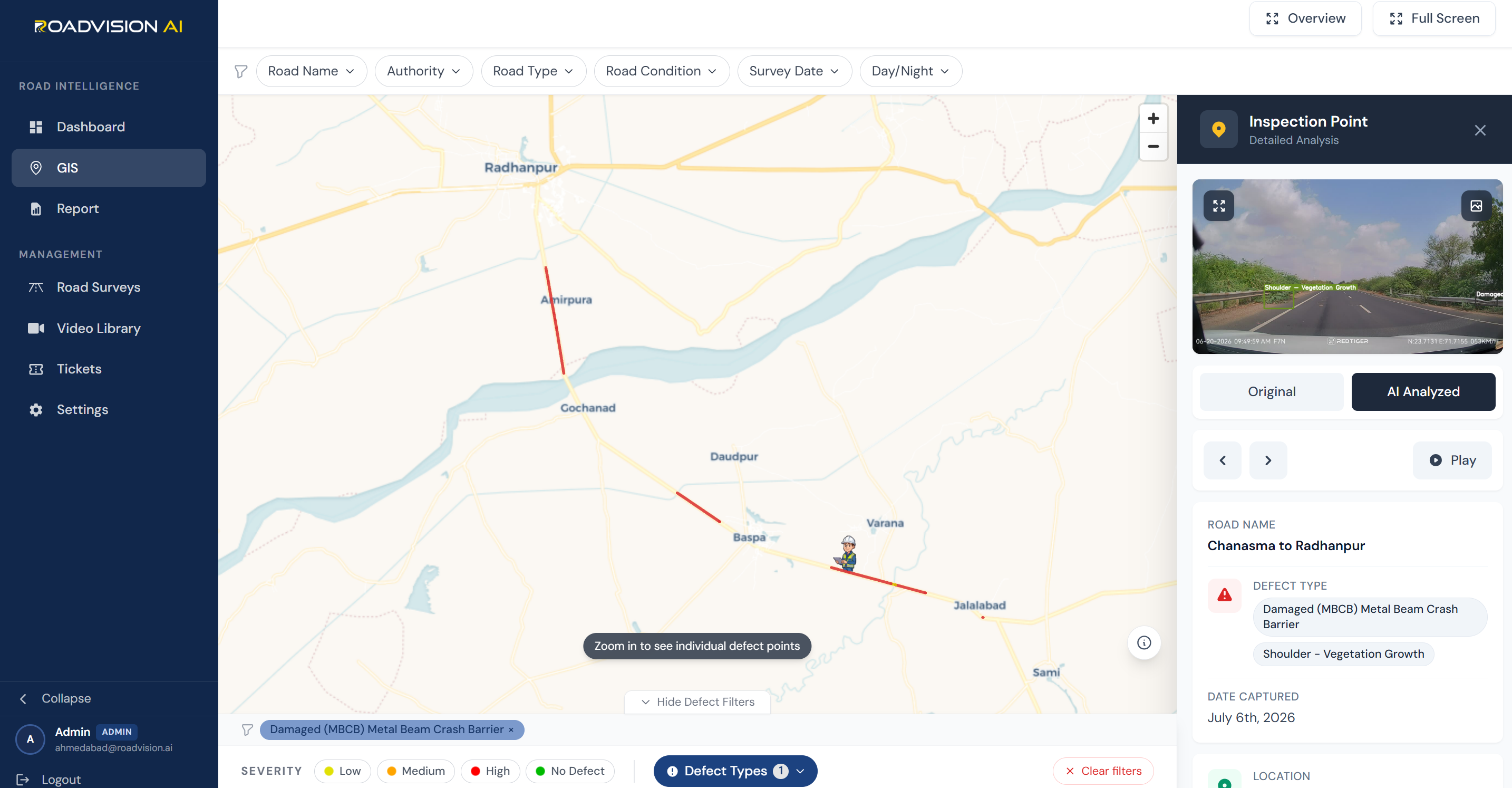
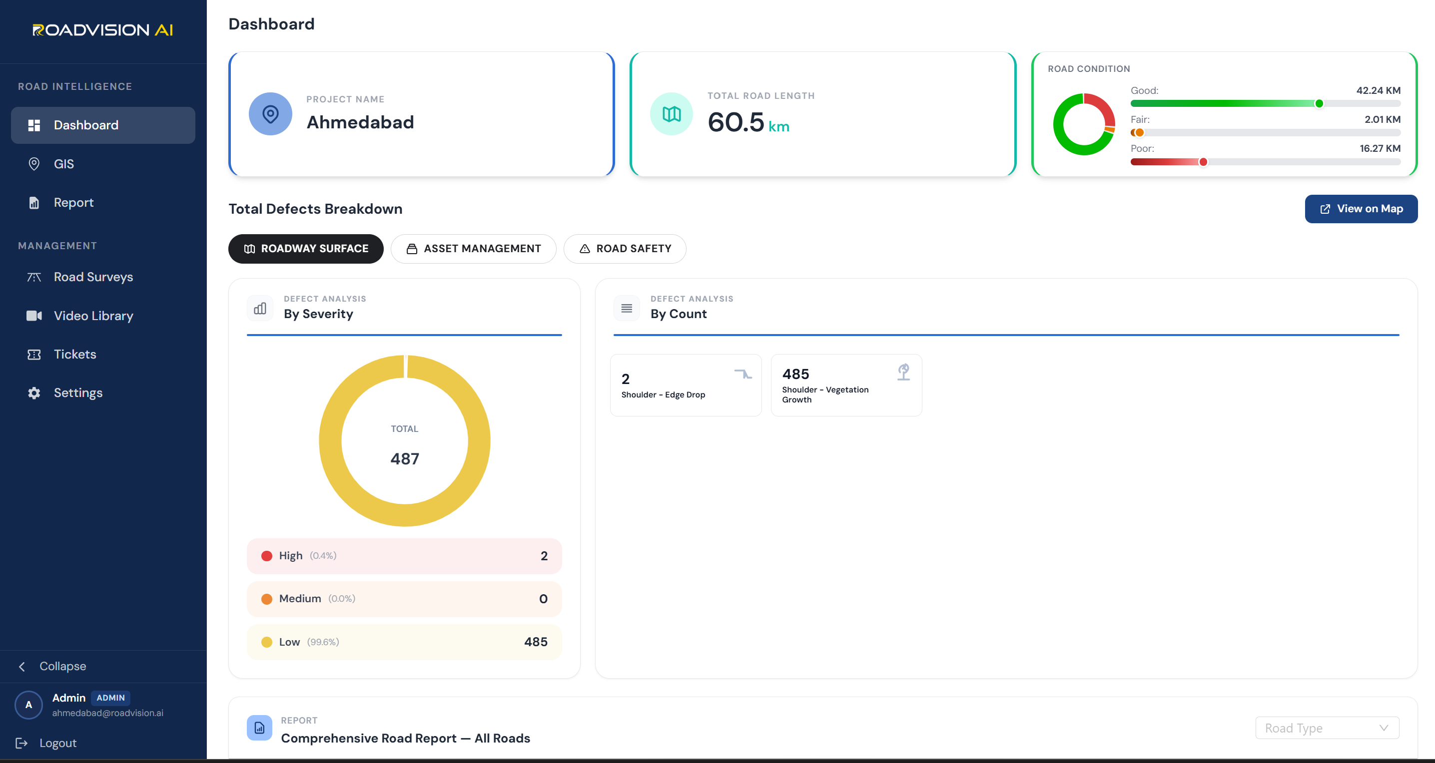
The survey gave the road authority its first geo-tagged, IRC-referenced safety picture of the Radhanpur–Chanasma corridor. Beyond the overall condition split, two patterns stood out as directly relevant to crash risk rather than general pavement wear.
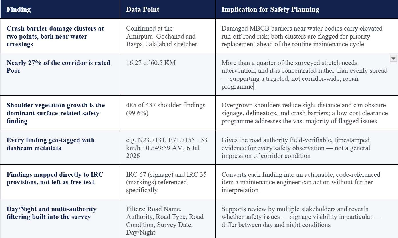
RoadVision AI's platform delivered five structured outputs from the Radhanpur–Chanasma survey each built to move a road safety finding from detection through to a defensible, code-referenced action item.
The location-specific view for field verification
Every observation linked to a code, not left as a general note
A dedicated review of the corridor's signage against code
A dedicated review of markings against code
The visual layer behind every finding
The Radhanpur–Chanasma survey gave the road authority a safety picture it did not have before one that is geo-tagged, risk-classified, and directly referenced against the codes its own engineers already work to.
The same AI-based methodology can be re-run on this corridor, or extended to others, at a fraction of the time and cost of mobilising a full expert-panel Road Safety Audit.
The two crash-barrier clusters near water crossings are now exact, field-verifiable locations not a general sense that 'the road needs attention.'
IRC 67 and IRC 35 compliance are now assessed on their own, code-referenced terms, giving the authority a defensible basis to scope signage and remarking budgets separately from general maintenance.
Every finding from crash barrier damage to shoulder vegetation growth comes with a severity tier and a location, letting the authority sequence spend by actual risk rather than by which section was inspected most recently
For state and district road authorities, PWD safety cells, and engineering teams evaluating AI-based road safety survey methodology.
RoadVision AI surveyed the full 60 km Radhanpur–Chanasma Road in Gujarat using a vehicle-mounted dashcam rig. The survey covered the villages of Radhanpur, Amirpura, Gochanad, Daudpur, Baspa, Varana, Jalalabad, and Sami, identifying and geo-tagging road safety concerns, classifying each by risk, and mapping findings to the relevant IRC provisions, including dedicated IRC 67 signage and IRC 35 marking compliance assessments.
Each detected finding a damaged crash barrier, a signage gap, a marking deficiency, or a shoulder condition issue is classified by RoadVision AI's computer vision engine based on the type and severity of the defect and its likely safety consequence. High-severity findings, such as damaged crash barriers near water crossings, are flagged for priority action, while lower-severity findings such as shoulder vegetation growth are logged for routine maintenance scheduling.
IRC 67 governs road signage its design, placement, and visibility requirements —while IRC 35 governs road markings. Rather than folding these into a general defect list, RoadVision AI runs each as a dedicated compliance evaluation across the full corridor, flagging specific signage or marking deficiencies against the applicable clause so the road authority can scope and budget each work stream independently.
A traditional RSA relies on a multi-disciplinary expert panel physically walking or driving the corridor thorough, but slow and expensive to mobilise, which is why many district-connecting roads go long periods without one. This AI-based survey covers the full 60 km corridor via vehicle-mounted dashcam capture, processes the footage through an AI engine for consistent, code-referenced classification, and can be repeated far more frequently than a full-panel audit, without replacing the value of periodic expert review.

The Autonomous Road Engineer
AI-powered road condition monitoring, asset management, & infrastructure intelligence helping agencies move from reactive maintenance to predictive road management.


.webp)
.webp)
.webp)