For decades, road inspection has meant sending a person an engineer, technician, or field inspector out to physically examine a stretch of pavement, note down defects, and report back. It's a method that has worked, but it's slow, expensive, inconsistent, and fundamentally limited by how much ground one person can cover in a day. As road networks grow larger and more heavily used, this manual approach is becoming harder to sustain.
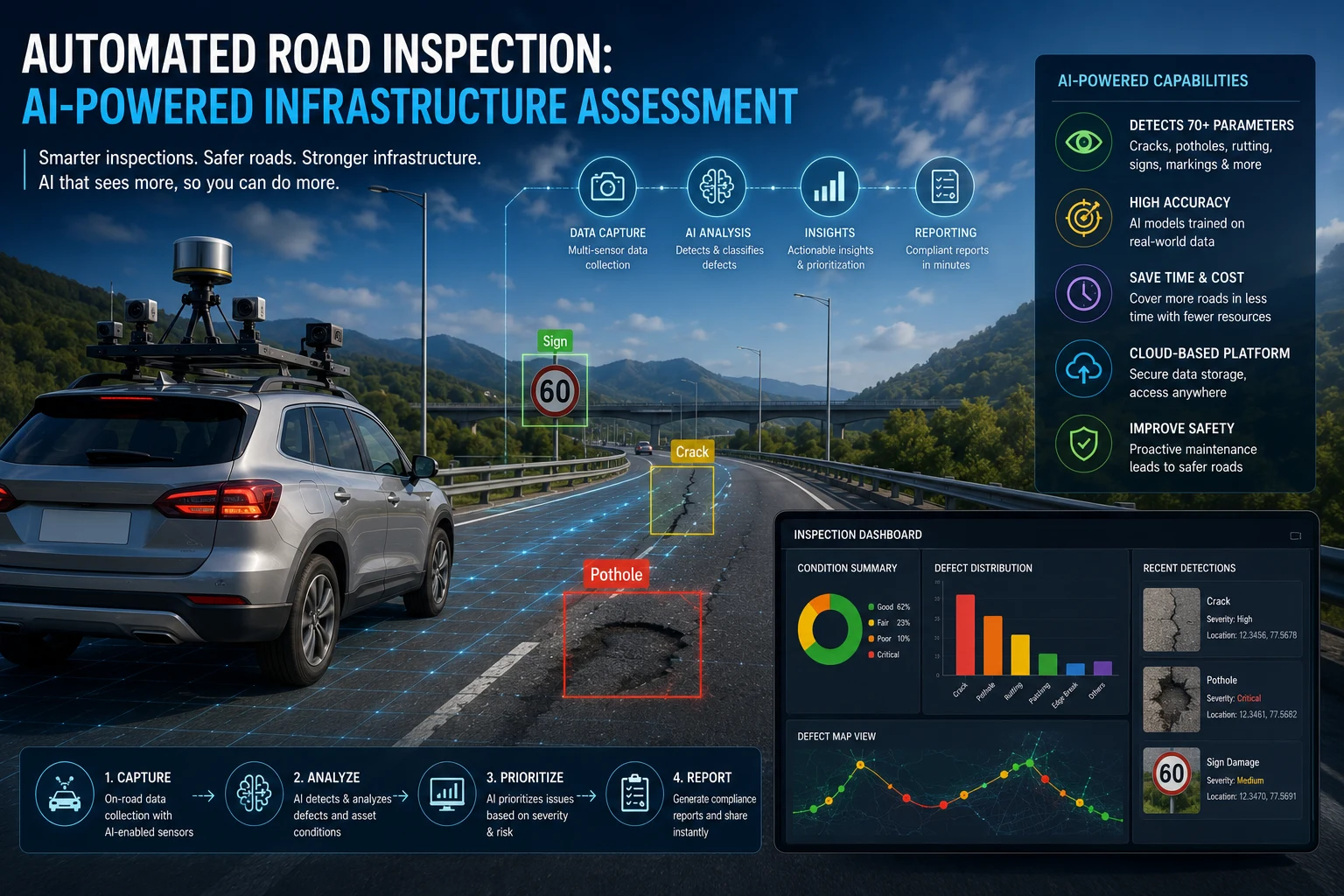
Automated road assessment & highway inspection offers a different path forward. By combining vehicle-mounted cameras, sensors, and AI-powered analysis, automated systems can survey road networks continuously, consistently, and at a fraction of the cost of traditional manual methods. In this blog, we'll explore what automated road inspection actually involves, how the technology works, the benefits it delivers, and what agencies should consider before adopting it.
Automated road assessment system | Highway Asset Management Software
What Is Automated Road Inspection?
Automated road inspection refers to the use of technology rather than manual visual assessment to detect, classify, and document road surface Inspection conditions. Instead of an inspector walking or slowly driving along a road with a clipboard, automated systems use cameras, LiDAR, accelerometers, and AI models to capture and analyze road data as vehicles travel at normal or near-normal speeds.
The output isn't just a list of observations it's structured, geotagged data: exact defect locations, severity classifications, and condition trends over time, all generated with minimal manual effort. This shifts inspection from a periodic, labor-intensive event into a continuous, scalable process.
Why Manual Road Inspection Is Reaching Its Limits
Traditional manual inspection methods have served road authorities for generations, but they come with structural limitations that are increasingly difficult to work around:
Slow Coverage: A manual inspection team can only cover a limited number of road-kilometers per day, meaning large networks may only be fully surveyed once a year or less.
Subjectivity and Inconsistency: Different inspectors can rate the same defect differently, leading to inconsistent data that's hard to compare or trend over time.
High Labor Costs: Skilled inspection staff are expensive to train and retain, and budget constraints often mean too few inspectors for the size of the network.
Safety Risks: Inspectors working on or near live traffic lanes face genuine safety risks, particularly on high-speed roads or during poor weather
Delayed Reporting: Manual data entry and reporting processes can introduce significant delays between when a defect is spotted and when it's logged into a system that triggers repair action.
Incomplete Records: Paper-based or loosely structured digital records often make it difficult to track a specific road segment's condition history over multiple years.
These limitations don't just create inefficiency they directly affect how quickly hazards are identified and fixed, with real consequences for road safety and vehicle damage.
How Automated Road Assessment & Highway Inspection Works
1. Data Capture
Automated inspection begins with data collection, typically using one or more of the following methods:
Dedicated survey vehicles equipped with high-resolution cameras, LiDAR, and accelerometers, specifically designed for detailed network-level surveys
Standard fleet vehicles—buses, municipal service vehicles, delivery vans—retrofitted with dashcams to passively collect data during normal operations
Drones, used for aerial inspection of highways, bridges, or hard-to-access infrastructure
Mobile devices, used in some lower-cost or citizen-reporting-integrated inspection programs
2. Sensor and Image Processing
As data is captured, onboard or cloud-based processing systems begin analyzing it. Video and image data is processed using computer vision, while accelerometer and gyroscope data captures vibration patterns associated with surface irregularities.
3. AI-Powered Defect Detection
Trained AI models typically convolutional neural networks or object detection frameworks automatically identify and classify defects within the captured data, including potholes, cracking (longitudinal, transverse, and alligator cracking), rutting, raveling, and surface roughness.
4. Sensor Fusion for Accuracy
Many systems combine visual detection with vibration and depth data to reduce false positives, cross-validating that a visually detected anomaly corresponds to an actual physical defect rather than a shadow, stain, or repair patch.
5. Severity Classification and Scoring
Detected defects are automatically classified by severity, often mapped to standardized condition indices used in pavement management, helping ensure automated results remain compatible with established engineering frameworks and historical data.
6. GPS Geotagging and Mapping
Every detected defect is tagged with precise location data and layered onto a GIS-based map, giving inspection teams and planners an accurate, visual representation of network condition.
7. Reporting and System Integration
Processed results feed into dashboards and, in more advanced deployments, directly into maintenance management systems automatically generating work orders and prioritized repair lists without manual data entry.
Key Technologies Behind Automated Road Assessment System
Computer Vision and Deep Learning: The core technology enabling automated detection and classification of visible road surface defects from image and video data.
LiDAR: Provides precise 3D surface measurements, useful for detecting rutting, depth of cracking, and surface deformation with high accuracy.
Accelerometers and IMU Sensors: Capture vibration data as a vehicle passes over surface irregularities, supporting sensor fusion validation.
Edge Computing: Enables initial data processing directly on the vehicle or device, reducing the bandwidth required to transmit raw video data to the cloud.
Cloud-Based AI Processing: Powers the more complex analysis, pattern recognition, and historical trend modeling that support long-term infrastructure planning.
GIS and Asset Management Integration: Ensures automated inspection data can be meaningfully connected to an agency's existing infrastructure records and maintenance workflows.
Benefits of Automated Road Inspection
For Transportation Agencies and Municipalities
Dramatically Increased Coverage: Automated systems can survey far more road-kilometers per day than manual inspection teams, enabling more frequent, comprehensive network assessment.
Lower Cost per Kilometer: Reduced reliance on specialized inspection crews significantly lowers the cost of surveying large networks, particularly when using existing fleet vehicles.
Consistent, Objective Data: AI-based classification applies the same criteria network-wide, eliminating the inspector-to-inspector variability common in manual surveys.
Improved Safety: Reducing the need for personnel to physically inspect roads, particularly on high-speed or high-risk segments, lowers safety exposure for survey staff.
Faster Time-to-Action: Automated data processing and integration with maintenance systems shortens the time between defect detection and repair dispatch.
For Road Users
Faster Hazard Resolution: More frequent, comprehensive monitoring means defects are identified and addressed sooner, reducing accident and vehicle damage risk.
Smoother, Safer Roads: Continuous monitoring supports more proactive maintenance, reducing the likelihood of small issues growing into major hazards.
For Engineers and Planners
Better Long-Term Planning Data: Consistent, historical condition data supports more accurate deterioration modeling and long-term capital planning.
Reduced Administrative Burden: Automating data collection and initial classification frees engineering staff to focus on higher-value analysis and decision-making rather than manual data compilation.
Real-World Applications of Automated Road Inspection
Network-Level Condition Surveys: Highway and transportation authorities use automated survey vehicles to conduct comprehensive network assessments far faster than traditional manual crews, often completing surveys that once took months in a matter of weeks.
Municipal Fleet-Based Monitoring: Cities are increasingly equipping buses, waste collection vehicles, and other municipal fleets with dashcams to passively contribute ongoing road condition data during normal operations.
Post-Weather Event Assessment:AI in road inspection software is used to quickly assess road conditions following storms, freeze-thaw cycles, or flooding, helping prioritize emergency repairs.
Pavement Management System Integration: Many agencies integrate automated inspection data directly into their pavement management system, supporting more accurate, data-driven long-term maintenance planning.
Bridge and Structural Inspection Support: While distinct from surface-level road inspection, drone-based automated inspection is increasingly used to supplement structural assessments of bridges and elevated roadways.
What to Look for in an Automated Road Inspection Solution
Detection Accuracy: Verify documented accuracy rates across a range of lighting, weather, and road surface conditions relevant to your network.
Compatibility with Existing Standards: Confirm that defect classification aligns with, or can be mapped to, the condition indices and standards your agency already uses.
Integration Capabilities: Ensure the system can integrate smoothly with your existing GIS and asset or pavement management software.
Scalability: Consider whether the solution can grow from a pilot project to full network coverage without major cost or operational barriers.
Data Ownership and Export Options: Clarify data ownership and portability terms, particularly if you may want to switch vendors or platforms in the future.
Turnaround Time: Understand how quickly raw data is processed into actionable, structured results after collection.
Challenges in Adopting Automated Road Inspection
Initial Investment: Hardware, software licensing, and integration work require upfront capital, though costs are generally lower than establishing an equivalent manual survey capability at scale.
Environmental Variability: Detection accuracy can be affected by weather, lighting, and road surface diversity, requiring well-trained, regularly validated AI models.
Change Management: Shifting from manual to automated inspection workflows requires staff training and, in some cases, organizational restructuring of inspection roles.
Data Volume Management: Processing and storing large volumes of video and sensor data requires robust cloud infrastructure and efficient data management strategies.
Verification for Critical Decisions: For high-stakes structural or safety determinations, some degree of manual verification is typically still required alongside automated detection.
The Future of Automated Road Inspection
As AI models, sensor technology, and fleet-based data collection continue to mature, automated road inspection is likely to become the standard approach for road condition assessment. Emerging trends include:
Continuous, Always-On Monitoring: Rather than periodic automated surveys, fleet-based continuous monitoring will increasingly provide near-real-time network condition updates.
Deeper Predictive Capabilities: Automated inspection data will increasingly feed into predictive deterioration models, shifting agencies from reactive to genuinely proactive maintenance planning.
Integration with Broader Infrastructure Intelligence Platforms: Automated inspection is likely to become one input among many within unified infrastructure intelligence systems that combine condition, traffic, and asset data.
Expansion to Additional Asset Types: Beyond pavement surfaces, automated inspection technology is expanding to cover signage, drainage infrastructure, and roadside safety features within the same data collection process.
Autonomous and Connected Vehicle Integration: As vehicle connectivity grows, automated inspection may increasingly draw on data generated directly by connected and autonomous vehicles traveling the network.
Conclusion
Automated road inspection represents a fundamental shift in how road networks are assessed from slow, labor-intensive manual surveys to continuous, AI-powered road monitoring. By combining computer vision, sensor fusion, and GIS integration, automated systems allow agencies to survey more road, more often, more consistently, and at lower cost than traditional methods ever allowed. While implementation requires thoughtful planning around integration, data quality, and organizational change, the long-term benefits faster hazard detection, better planning data, and more efficient use of maintenance budgets make automated road inspection an increasingly essential capability for modern infrastructure management.
Frequently Asked Questions (FAQs)
1. What is automated road inspection?
Automated road inspection uses cameras, sensors, and AI to detect, classify, and document road surface conditions, replacing or supplementing traditional manual visual inspection methods.
2. How accurate is automated road inspection compared to manual methods?
Well-trained AI models can achieve high detection accuracy, often exceeding 90% under good conditions, while also providing more consistent, objective classification than manual inspection, which can vary between individual inspectors.
3. What technologies are used in automated road inspection systems?
Common technologies include computer vision and deep learning models, LiDAR, accelerometers, GPS geotagging, edge computing, and cloud-based AI processing platforms.
4. Can automated road inspection replace manual inspectors entirely?
Not entirely. While automated systems handle the majority of routine detection and classification, manual verification is often still required for critical structural assessments or ambiguous cases.
5. How does automated road assessment reduce costs?
By using existing fleet vehicles or efficient dedicated survey vehicles combined with AI processing, automated inspection significantly reduces the labor costs associated with large-scale manual survey teams.




.webp)
.webp)
.webp)