Canada is home to over 1.04 million kilometres of roads and for nearly half the year, a significant portion of that network is under siege. Snow, ice, freeze-thaw cycles, salt-induced corrosion, and pothole formation make Canadian winters the most punishing road maintenance environment on the planet. Provinces like Ontario, Quebec, Alberta, and British Columbia face annual infrastructure repair bills running into the billions, while road fatalities and vehicle damage claims spike every November through March.
Yet despite the scale of the challenge, many highway authorities across Canada still rely on inspection methods that would have been familiar to road crews decades ago manual visual surveys, paper-based condition reporting, and reactive maintenance triggered only after damage becomes severe enough to be visible. These approaches are too slow, too inconsistent, and far too costly for a country where winter conditions can transform a structurally sound road into a hazardous liability overnight.
Highway inspection software powered by artificial intelligence, computer vision, and real-time data pipelines is changing that reality. And RoadVision AI is leading the charge, delivering purpose-built solutions designed specifically for the demands of Canadian road networks and the unique brutality of the Canadian winter.
To understand why AI-powered highway inspection software matters so deeply in the Canadian context, consider the numbers. Environment and Climate Change Canada reports that winter weather is a contributing factor in approximately 30% of all road fatalities nationwide. The Canadian Automobile Association estimates that poor road conditions potholes, surface cracking, inadequate winter maintenance cost Canadian drivers over $3 billion annually in vehicle damage alone.
Beyond individual vehicle damage, the infrastructure costs are staggering. A single pothole left unaddressed through one freeze-thaw cycle can expand from a minor surface crack to a sub-base failure requiring full pavement reconstruction a repair that costs 40 to 80 times more than early intervention would have. Multiply that dynamic across thousands of kilometres of provincial highways and municipal roads, and the case for proactive, technology-driven inspection becomes undeniable.
The winter problem in Canada is not just a seasonal inconvenience it is a structural infrastructure challenge that demands a smarter, faster, and more data-rich response than manual inspection can provide.
Highway inspection software refers to a technology platform that automates the detection, classification, documentation, and prioritization of road surface defects and hazardous conditions. Modern AI-powered systems go far beyond simple dashcam footage they apply machine learning models trained on vast libraries of road condition imagery to identify and categorize defects with speed and consistency no human inspector can match.
Core capabilities of advanced highway inspection software include:
RoadVision AI's platform delivers all of these capabilities in a system engineered for Canada's climate extremes, operational constraints, and regulatory environment.
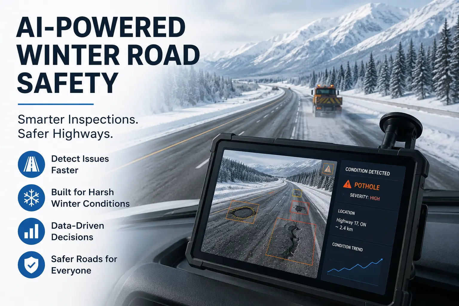
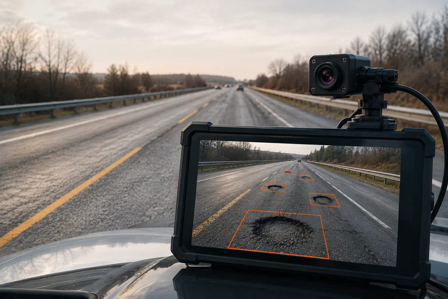
RoadVision AI's system is built around a vehicle-mounted sensor suite that integrates high-resolution cameras, LiDAR, and inertial measurement units (IMUs) into a compact, weather-sealed unit that can be installed on existing maintenance vehicles, patrol trucks, or dedicated inspection fleets. Unlike fragile laboratory-grade equipment, our hardware is engineered to operate reliably at temperatures as low as –40°C a non-negotiable requirement for northern Ontario, the Prairies, and the territories.
As vehicles travel their normal maintenance routes, the system continuously captures high-resolution road surface imagery and 3D point cloud data, building a comprehensive digital record of pavement condition in real time without requiring dedicated inspection runs that add cost and time.
The captured data is processed by RoadVision AI's multi-model detection engine, which applies separate specialized neural networks for different defect categories surface cracking, pothole geometry, icing signatures, frost heave displacement, and more. Each model was trained on annotated Canadian road condition datasets encompassing all four seasons, ensuring high accuracy even on partially snow-covered or ice-glazed surfaces where generic international models consistently fail.
Detection outputs are classified by defect type, severity level, and urgency giving maintenance teams an immediately actionable picture rather than raw data requiring expert interpretation.
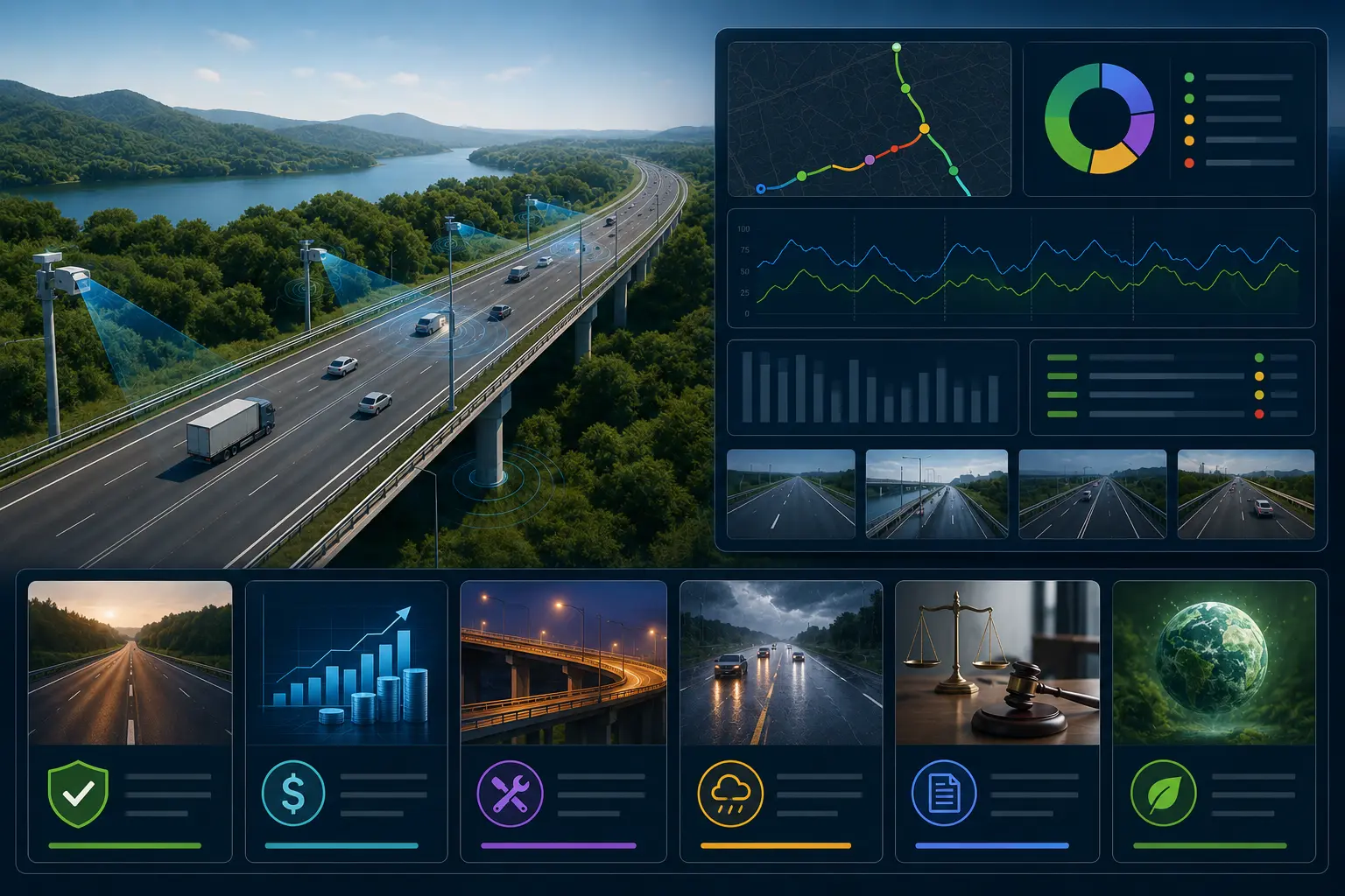
Every detected defect is automatically geo-tagged and plotted on RoadVision AI's live GIS dashboard, giving road authorities a continuously updated map of network condition across their entire jurisdiction. Maintenance managers can filter by defect type, severity, road classification, or geographic region and drill down to view imagery and measurement data for any individual issue.
The dashboard integrates directly with Environment and Climate Change Canada weather feeds, overlaying current and forecast temperature, precipitation, and freeze-thaw cycle data onto the road condition map. This weather-aware view allows maintenance teams to predict where winter road damage will emerge next and pre-position resources accordingly.
RoadVision AI's predictive maintenance module combines current pavement condition scores, historical deterioration rates, seasonal weather modeling, and traffic loading data to generate a forward-looking maintenance priority queue. Rather than simply reacting to damage already visible, highway authorities can intervene at the earliest cost-effective moment before a sealed crack becomes an open pothole, and before a frost heave becomes a lane closure.
Provincial highway authorities and municipalities face significant reporting obligations under asset management frameworks including the Ontario Regulation 588/17, the Canadian Infrastructure Report Card standards, and Transportation Association of Canada (TAC) guidelines. RoadVision AI's platform auto-generates compliant condition assessment reports, defect inventories, and maintenance logs dramatically reducing the administrative burden on engineering teams.
Standard highway inspection approaches whether manual windshield surveys or basic dashcam systems break down precisely when Canadian road authorities need them most. Here is why winter creates unique demands that only purpose-built AI software can meet:
Visibility and Surface Ambiguity: Snow cover, road spray, and low winter sun angles make visual defect identification unreliable. RoadVision AI's system uses LiDAR-derived 3D surface models alongside visual data, detecting sub-surface deformation and frost heave that is completely invisible to the human eye or standard cameras.
Speed of Deterioration : A freeze-thaw cycle can open a new pothole in 48 hours. Manual inspection schedules typically quarterly or monthly simply cannot keep pace with winter's rate of damage creation. RoadVision AI's continuous monitoring, embedded in regular maintenance vehicle routes, ensures that new defects are captured within days of formation rather than weeks.
Crew Safety: Sending inspection personnel onto icy highway shoulders in winter conditions is a significant occupational safety liability. By embedding inspection capability into vehicles already operating on the network, RoadVision AI eliminates the need for exposed roadside inspection activities during hazardous winter conditions.
Salt and Chemical Damage: Road de-icing salts accelerate pavement surface condition ravelling and concrete spalling in ways that are difficult to detect visually in early stages. RoadVision AI's spectral analysis capabilities can identify salt-induced micro-damage signatures before they progress to costly structural failures.
Provincial Highway Authorities Ministries of Transportation across Ontario, Alberta, British Columbia, Quebec, and beyond use RoadVision AI to maintain continuous condition inventories across thousands of kilometres of numbered highways, enabling compliance with provincial asset management regulations and optimizing annual capital maintenance budgets.
Municipal Road Networks Canadian cities and regional municipalities manage extensive local road networks with limited inspection budgets. RoadVision AI's cost-effective mobile deployment model allows municipal public works departments to achieve comprehensive annual network assessments at a fraction of the cost of traditional contracted inspection programs.
Remote and Northern Communities Highway corridors in Northern Ontario, Northern British Columbia, the Yukon, and the Northwest Territories face extreme isolation alongside extreme weather. RoadVision AI's offline-capable edge processing allows data collection in areas with no cellular connectivity, syncing inspection records automatically when vehicles return to network coverage.
Private Highway and Toll Road Operators Concession operators managing toll highways and bridges have contractual obligations to maintain specific pavement condition standards. RoadVision AI provides continuous, audit-ready documentation that demonstrates compliance and supports proactive capital renewal planning.
The financial case for AI-powered highway inspection software in Canada is compelling. Studies by provincial transportation ministries consistently show that every dollar spent on proactive pavement preservation prevents four to eight dollars in future rehabilitation costs. RoadVision AI's platform typically enables:
Beyond the financial numbers, road authorities also report meaningfully improved staff productivity, faster emergency response to hazardous conditions, and stronger public confidence when citizens can see that road safety decisions are driven by real data rather than reactive complaint management.
Many highway inspection software providers offer capable platforms for temperate climates. Very few have invested in the deep engineering and dataset development required to perform reliably under Canadian winter conditions. RoadVision AI was built from the ground up with Canadian road networks and Canadian winters as the design baseline not an afterthought.
Our platform is backed by a team with direct experience working alongside Canadian transportation ministries, municipal public works departments, and northern road authorities. We understand the regulatory landscape, the budget cycles, the union operating environments, and the operational reality of maintaining roads when temperatures have not risen above freezing in three months.
We offer flexible engagement models including pilot programs scoped to a defined road corridor or municipality so road authorities can validate performance in their specific environment before committing to full network deployment.
Canada's highway network is one of the country's most critical and costly public assets and winter is its greatest adversary. The combination of freezing temperatures, freeze-thaw cycling, heavy salt application, and high traffic loading creates a deterioration environment that overwhelms traditional inspection and maintenance approaches year after year.
RoadVision AI's highway inspection software gives Canadian road authorities the tools to fight back with continuous AI-powered defect detection, real-time condition mapping, predictive maintenance scheduling, and automated compliance reporting that works as hard in January as it does in July. The result is safer roads, lower long-term infrastructure costs, and a road network that serves Canadians reliably through every season.
Ready to transform how your highway network handles winter? Contact RoadVision AI today to schedule a demonstration or discuss a pilot program for your jurisdiction.
The platform detects a comprehensive range of defects including longitudinal and transverse cracking, alligator cracking, potholes, rutting, ravelling, edge deterioration, frost heave, surface icing, and deicing salt damage. Each defect is classified by type and severity level using standardized pavement condition index criteria.
RoadVision AI's system is designed to operate through a wide range of winter conditions. While heavy, active snowfall at accumulation rates exceeding 5 cm per hour will reduce optical sensor performance, the LiDAR component continues to function effectively. The system also flags images captured in degraded visibility conditions so operators can manually review or reschedule passes for those segments.
No. RoadVision AI's vehicle-mounted hardware installs in under two hours and operates automatically once a vehicle begins its route. The dashboard interface is designed for use by transportation engineers and maintenance supervisors without specialized data science skills. Full onboarding and training is included with every deployment.
Yes. RoadVision AI supports data export in standard formats including GeoJSON, Shapefile, CSV, and direct API integration with leading asset management platforms used by Canadian transportation agencies, including IBM Maximo, Cartegraph, and custom provincial systems.

The Autonomous Road Engineer
AI that is transforming road infrastructure, from reactive to predictive.
.webp)