
This is a corridor-level account from RoadVision AI's road survey programme for NHAI, covering three consecutive sections of NH-34, now renumbered NH-12, through West Bengal: Krishnagar to Berhampore (Km 115.00 to Km 193.00), Berhampore to Farakka (Km 191.700 to Km 292.300), and Farakka to Raiganj (Km 295.000 to Km 395.000). Together they run about 280 km, and the survey data shows that the corridor's maintenance problems change character as it runs north.

NH-12, formerly NH-34, is described as the primary North–South arterial lifeline in West Bengal, connecting South Bengal to North Bengal, the North-Eastern states, and neighbouring countries including Bangladesh, Bhutan and Nepal. The three sections surveyed here follow it from Nadia to Uttar Dinajpur.
Krishnagar–Berhampore, Km 115.00 to Km 193.00, passes through the Nadia and Murshidabad districts. It was four-laned on a BOT Annuity basis at an awarded cost of ₹1,934.1 crore, against a total capital cost of ₹2,582.4 crore, with the agreement signed on 16 June 2011 and work appointed to start on 10 January 2012. A completion certificate has since been issued.
Berhampore–Farakka runs from Km 191.700 to Km 292.300, ending at Farakka, where the new four-lane Farakka Bridge crosses the Ganga about 500 m downstream of the older Farakka Barrage, linking Murshidabad and Malda districts. The 5.468 km twin two-lane bridge project has been reported as nearing completion, easing a severe bottleneck on North–South traffic.
Farakka–Raiganj, Km 295.000 to Km 395.000, is a roughly 100 km four-lane highway delivered on a DBFOT (BOT toll) basis. It passes through the Murshidabad, Malda and Uttar Dinajpur districts and the towns of Farakka, Kaliachak, Sujapur, Malda and Gajol.
The southern section was built under a BOT Annuity contract and the northern one under a toll concession, and a corridor of this length does not age uniformly from end to end. What NHAI's regional teams need is one consistent way to read all of it: the same detection, severity grading and chainage reference along the whole run, so that a finding near Km 150 and a finding near Km 350 can be compared directly.
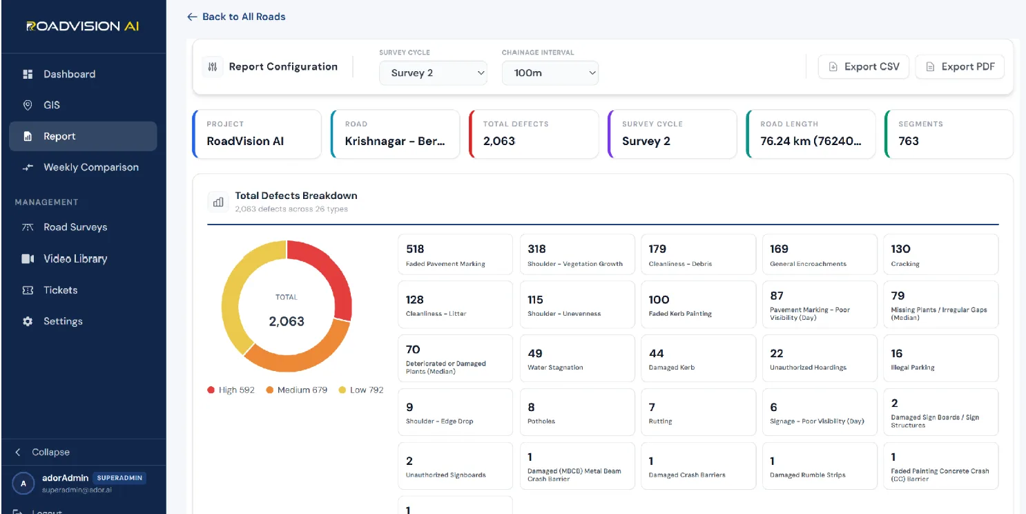
Survey 2 covered 76.24 km of this section in 763 segments at a 100 m chainage interval and logged 2,063 findings across 26 defect types. By severity, 592 (28.7%) are High, 679 (32.9%) Medium and 792 (38.4%) Low. Faded pavement marking is the largest single category at 518 findings (25.1%), followed by shoulder vegetation growth at 318 (15.4%), roadside debris at 179 (8.7%), general encroachments at 169 (8.2%) and cracking at 130 (6.3%).
Cleanliness findings, debris and litter together, come to 307 (14.9%), and median plantation problems, missing or damaged plants, to 149 (7.2%). Encroachments, illegal parking and unauthorised hoardings add a further 207 (10.0%). Much of this section's load is therefore roadside upkeep and clutter, which is a matter of routine management more than pavement repair. Within the seven roadway-surface categories alone, which total 636 findings, shoulder vegetation growth accounts for half (50.0%) and standing water for just 7.7%.
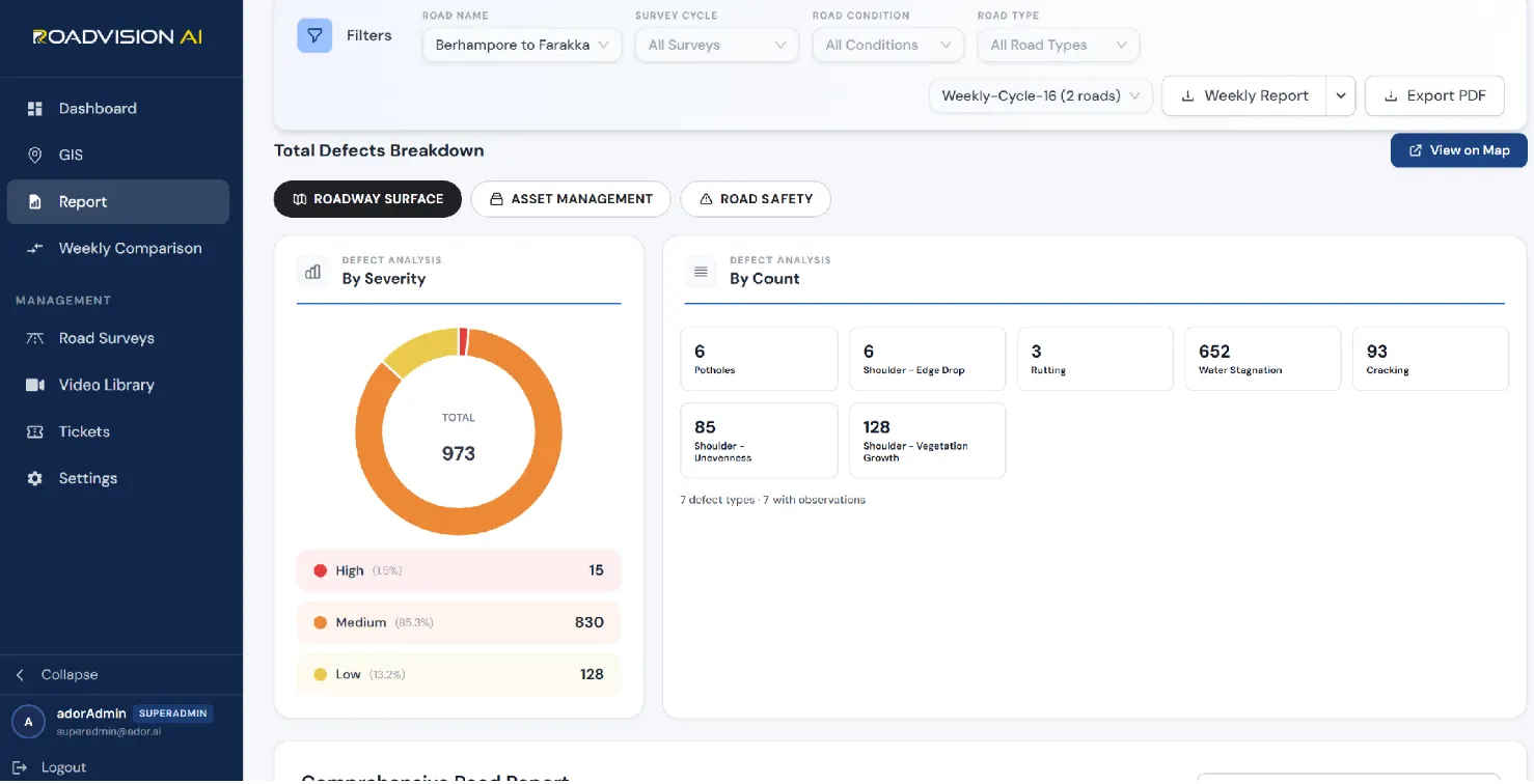
Across the surveys recorded on this section, RoadVision AI has logged 973 roadway-surface findings across seven defect types: 15 (1.5%) High, 830 (85.3%) Medium and 128 (13.2%) Low. The picture has changed completely from the south. Water stagnation is now the largest category at 652 findings (67.0%), followed by shoulder vegetation growth (128, 13.2%), cracking (93, 9.6%) and shoulder unevenness (85, 8.7%). The 15 High-severity findings equal the combined count of potholes (6), shoulder edge drop (6) and rutting (3), so the urgent items are very few.
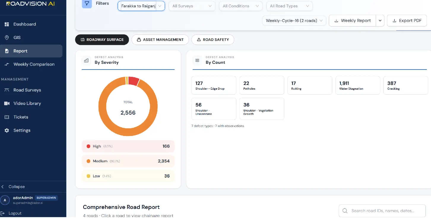
On Farakka–Raiganj the surveys recorded to date show 2,556 roadway-surface findings across the same seven defect types: 166 (6.5%) High, 2,354 (92.1%) Medium and 36 (1.4%) Low. Water stagnation accounts for 1,911 findings (74.8%), three-quarters of the total, followed by cracking at 387 (15.1%) and shoulder edge drop at 127 (5.0%). The Medium band is exactly the combined count of water stagnation, cracking and shoulder unevenness, so this section's work is dominated by drainage and surface upkeep, while the 166 High-severity findings form a short priority list.
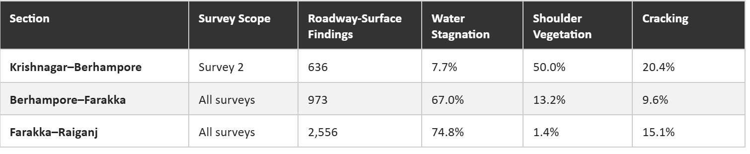
Moving north, standing water rises from under 8% of roadway-surface findings to about three-quarters, while shoulder vegetation growth falls from half to under 2%. The corridor does not have one maintenance problem; it has a southern one, about vegetation, markings and roadside clutter, and a northern one, about drainage.
Whether a section is maintained under a BOT Annuity contract or a toll concession, the survey gives NHAI's regional teams a defect ID, chainage and survey reference for every finding, and a later survey of the same chainage shows whether it has been closed out. On the two northern sections, where standing water dominates, that check matters most: a drainage fix only counts once the same chainage is found clear on the next pass.
RoadVision AI is committed to continuous AI-based road monitoring along the full Krishnagar–Raiganj corridor of NH-12, giving NHAI a single, consistent, chainage-level record from Nadia to Uttar Dinajpur. A corridor that changes character as it runs north needs a record that can show where the problems are, what kind they are, and whether they are being put right.

The Autonomous Road Engineer
AI-powered road condition monitoring, asset management, & infrastructure intelligence helping agencies move from reactive maintenance to predictive road management.


.webp)
.webp)
.webp)