
This is a project-level account from RoadVision AI's weekly highway survey programme for NHAI, covering the six-laning of the Agra to Etawah Bypass section of NH-2 (now NH-19), from Km 199.660 to Km 323.525 in Uttar Pradesh, executed on a Build-Operate-Transfer (Toll) basis. It sets out why the corridor warrants continuous monitoring, how the survey data is collected and processed, what the first baseline round found, and how NHAI will use this record to hold the concessionaire to its maintenance obligations over the life of the concession.
The Agra to Etawah Bypass section of NH-2 (renumbered NH-19) runs approximately 124.52 km through the Agra, Firozabad, Mainpuri and Etawah districts of Uttar Pradesh. It was taken up for six-laning under NHDP Phase V and awarded on a Build-Operate-Transfer (Toll) basis to AE Tollway Private Limited (AETPL), a special purpose vehicle of IRB Infrastructure Developers Ltd. The project carries an estimated cost of approximately ₹2,650 crore, under a concession agreement dated 1 September 2015 that runs for 24 years from the appointed date, during which AETPL collects user fees to recover its investment.
A concession of this scale and duration creates a maintenance obligation that outlasts any single construction milestone: AETPL is contracted to keep the corridor to a defined standard for 24 years, funded by the tolls it collects from the travelling public over that period. That structure is precisely why the corridor needs an independent, continuously refreshed condition record not a one-time completion certificate, but a running account of whether the standard the concession requires is actually being met, month after month, for the length of the agreement.
Every finding from every survey round is recorded on a live GIS map spanning the corridor. Each inspection point can be opened to reveal its exact location, the defect type flagged, and the underlying image or video frame, shown in both its original and AI-annotated form. For NHAI's RO West UP and its Agra Project Implementation Unit, this allows a summary finding to be traced back to the precise stretch of road and the corresponding photographic evidence.
Figure 1 shows an inspection point on the Agra–Etawah Bypass captured in July 2026, flagging faded pavement marking near Shikohabad, Firozabad district.
.webp)
The scale of this concession is itself a signal of the traffic the corridor carries and the standard it is expected to hold. A 124.52 km, ₹2,650 crore six-laning project, funded through toll revenue over 24 years, is not undertaken on a road with light or seasonal traffic; NHDP Phase V corridors of this size are reserved for routes carrying sustained, high-volume traffic that a four-lane configuration could no longer serve.
This has a direct bearing on how the corridor is surveyed and maintained. With toll-paying traffic moving through the stretch in both directions for most of the day, survey operations are planned to work within live traffic conditions, and maintenance obligations under the concession agreement are monitored and verified against that same operating reality not against a hypothetical low-traffic window.
The corridor comprises the Main Carriageway, Service Roads, Slip Lanes and Intersecting Roads, each surveyed independently in both directions — eight distinct facets of condition data at every chainage point. Consolidating this consistently across 124.52 km is not achievable through manual inspection at the frequency a live toll concession requires.
The more significant challenge, however, is not defect identification but defect verification. A single site visit can establish the corridor's condition on the day it is surveyed; it cannot establish whether a repainted marking, a repaired kerb, or a removed hoarding remains effective weeks later. Without round-on-round comparison against the same chainage points, a defect count is a static record. With it, the same data becomes evidence of whether AETPL's maintenance obligations under the concession are actually being met.
Surveys are conducted weekly across the full corridor, covering every road type and direction, by day. Each survey vehicle is fitted with a mounted dashcam that captures continuous footage while recording GPS coordinates at fixed intervals, allowing every frame to be tied to a precise chainage point. Both the raw footage and the AI-processed output are retained for every round, giving NHAI a complete and retrievable survey record for the life of the concession.
.webp)
Each frame is processed against a structured defect taxonomy covering pavement condition, road markings, signage, drainage, crash barriers and other roadside assets. Every finding generated through this process is recorded with a unique defect ID, precise GPS coordinates and chainage, a severity grade, and a confidence score from the detection model, ensuring that each entry carries a traceable basis.
As further rounds are completed, findings will also be checked against every prior round captured at the same location. This is what will enable round-on-round comparison going forward: a finding from one round can only be assessed against a finding from another if both are tied to the same location and classified using the same criteria — which is exactly what this baseline round now makes possible.
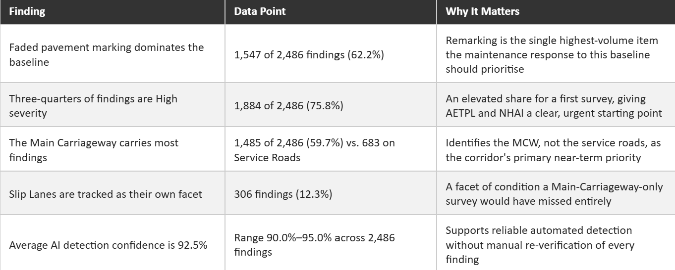
Round 1 of the survey programme (Survey ID N/02005/03001/UP_001_020726) recorded 2,486 findings across the corridor, establishing the baseline against which every future round will be measured. Of these, 1,884 (75.8%) were graded High severity, 424 (17.1%) Medium, and 178 (7.2%) Low — an elevated High-severity share for a first survey, giving AETPL and NHAI's Agra PIU a clear, urgent starting point rather than a gradual list to work through.
Faded pavement marking alone accounted for 1,547 of the 2,486 findings (62.2%), making it by a wide margin the single largest category on the corridor. By road type, the Main Carriageway carried the majority of findings (1,485, or 59.7%), ahead of the Service Road (683, 27.5%), Slip Lanes (306, 12.3%) and Intersecting Roads (12, 0.5%) identifying the MCW as the corridor's primary near-term priority, with marking renewal as the highest-volume single line item.
.webp)
The corridor is maintained under AETPL's BOT concession agreement, which binds the concessionaire to defined service-level obligations for the full 24-year term. NHAI is not required to rely on AETPL's own account of remedial work: each weekly report provides RO West UP and the Agra PIU with a defect ID, chainage and round reference sufficient to raise an Action Taken Report (ATR) request, with the following round's survey re-examining the same coordinates.
This is the enforcement mechanism the baseline round now puts in place. A finding is logged, an ATR is requested against it, AETPL undertakes the required action, and the next round's survey either confirms the defect has been resolved or shows that it persists. Verification will not depend on the concessionaire's representation; it will depend on the same chainage point being surveyed under the same method, round after round, for as long as the concession runs.
RoadVision AI is committed to continuous AI-based monitoring of the Agra–Etawah Bypass for the duration of its mandate with NHAI, and to supporting the concessionaire compliance that this monitoring enables. A 24-year toll concession is a long-term promise to the travelling public that the road will be kept to standard. Ensuring that promise is verified independently, round after round, is central to making this corridor safer for everyone who depends on it.

The Autonomous Road Engineer
AI-powered road condition monitoring, asset management, & infrastructure intelligence helping agencies move from reactive maintenance to predictive road management.


.webp)
.webp)
.webp)