
This is a project-level account from RoadVision AI's national weekly highway survey programme for NHAI, covering the six-lane flyover corridor at Boragaon, Gorchuk, Lokhra and Basistha Junction on the Guwahati Bypass, NH-27, from Km 146.172 to Km 162.620. It sets out why the stretch warrants continuous monitoring, how the survey data is collected and processed, what the programme has found to date, and how NHAI uses this record to enforce maintenance obligations against the concessionaire.
NH-27's Guwahati Bypass carries the majority of road traffic moving between the rest of India and the North Eastern Region. It forms part of NHAI's East-West Corridor and serves as the principal gateway into Assam, Meghalaya, Nagaland, Tripura and the wider Northeast. The corridor's original four-lane configuration could not accommodate this volume, and recurring congestion across multiple stretches led NHAI to commit to a full six-lane upgrade rather than incremental widening.
This upgrade includes four new flyovers, at Boragaon, Gorchuk, Lokhra and Basistha Junction. The Boragaon structure alone represents a construction cost of ₹25.32 crore; together with the Gorchuk, Basistha and Lokhra flyovers, the four structures account for over ₹110 crore of construction on this stretch, within a wider programme exceeding ₹300 crore that also covers service lanes and underpasses along the full 16.45 km corridor.
A corridor carrying this volume of traffic, with this scale of newly built infrastructure, requires maintenance oversight commensurate with its importance. There is no parallel route capable of absorbing traffic while a defect on this stretch goes unaddressed, which is the operating premise behind continuous weekly monitoring here.
.webp)
Every finding from every survey round is recorded on a live GIS map spanning the corridor, from Km 146.172 to Km 162.620. Each inspection point can be opened to reveal its exact location, the defect type flagged, and the underlying image or video frame, shown in both its original and AI-annotated form. For NHAI's Guwahati Regional Office and Project Implementation Unit, this allows a summary finding to be traced back to the precise stretch of road and the corresponding photographic evidence.
Figure 2 shows an inspection point captured in August 2026, flagging faded pavement marking and roadside debris at its exact position on the corridor.
.webp)
The scale of NHAI's investment in this corridor is itself an indicator of the traffic it carries. A six-lane upgrade with four dedicated flyovers is not undertaken on a road with light or moderate traffic; it reflects a corridor where at-grade junctions at Boragaon, Gorchuk, Lokhra and Basistha had become significant points of congestion, warranting grade separation rather than incremental improvement.
This has a direct bearing on how the corridor is surveyed and maintained. With high traffic volume moving through this stretch in both directions for most of the day, survey operations are planned to work within live traffic conditions rather than around low-traffic windows, and maintenance interventions are scheduled and verified accordingly.
The corridor comprises the Main Carriageway, Service Roads and Intersecting Roads, each surveyed independently in both directions, resulting in six distinct facets of condition data at every chainage point. Consolidating this consistently across 16.45 km and four junctions is not achievable through manual inspection at the frequency the corridor requires.
The more significant challenge, however, was not defect identification but defect verification. A single site visit can establish a road's condition on the day it is surveyed; it cannot establish whether a repair carried out after a previous visit, a repainted marking, a cleared drain, a removed hoarding, remained effective weeks later. Without round-on-round comparison, a defect count is a static record. With it, the same data becomes evidence of whether the maintenance programme is functioning as intended.
Surveys are conducted weekly across the full corridor, covering every road type and direction, by day and by night. Each survey vehicle is fitted with a mounted dashcam that captures continuous footage while recording GPS coordinates at fixed intervals, allowing every frame to be tied to a precise chainage point. Both the raw footage and the AI-processed output are retained for every round, providing NHAI with a complete and retrievable survey record.
.webp)
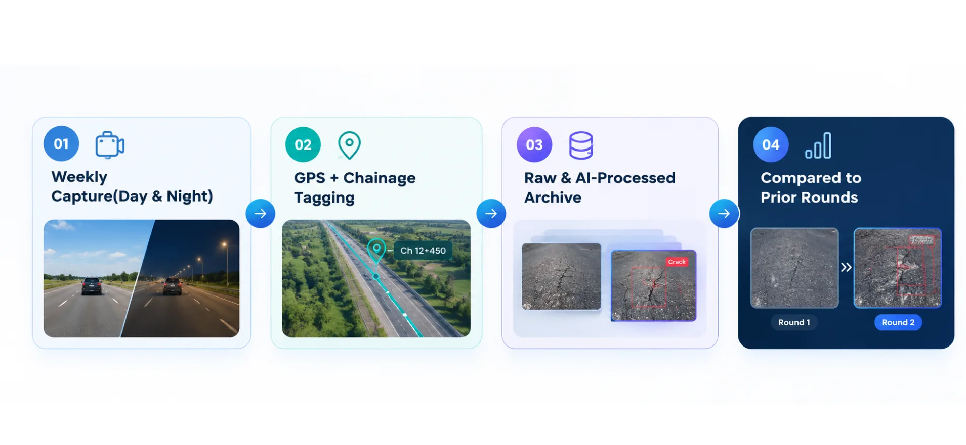
Each frame is processed against a structured defect taxonomy covering pavement condition, road markings, signage, drainage, barriers and other roadside assets. Every finding generated through this process is recorded with a unique defect ID, precise GPS coordinates and chainage, a severity grade, and a confidence score from the detection model, ensuring that each entry carries a traceable basis.
Findings are also checked against every prior round captured at the same location. This is what enables round-on-round comparison: a finding from one round can only be assessed against a finding from another if both are tied to the same location and classified using the same criteria.
.webp)
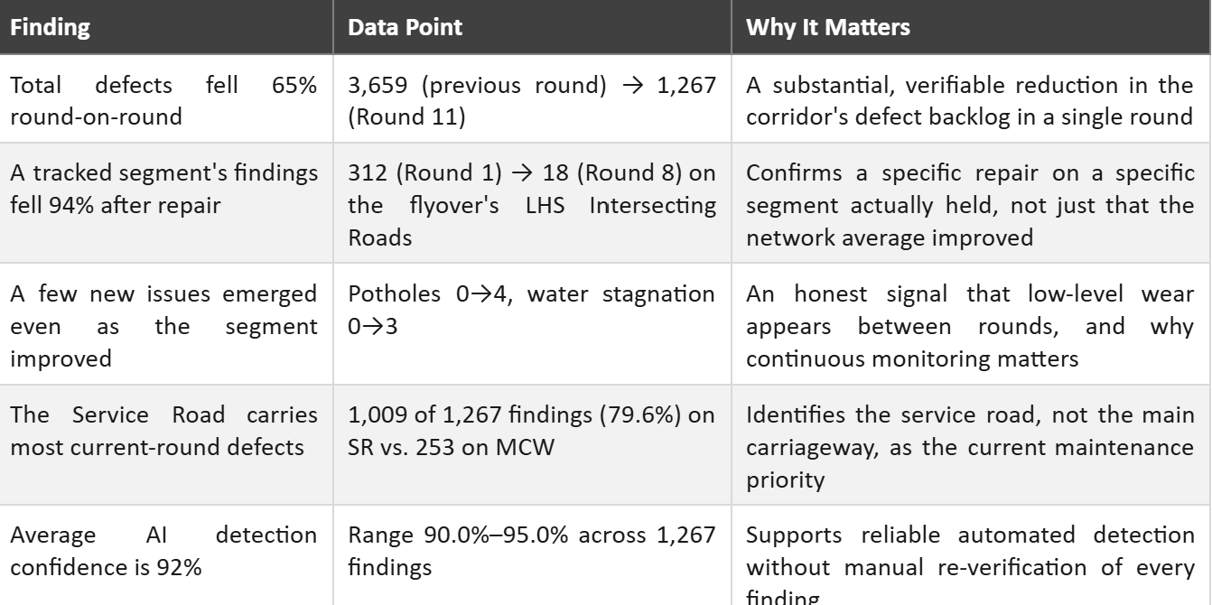
As of Week 12 of the survey programme, RoadVision AI has completed twelve weekly rounds on this corridor. The most recent full comparative cycle, Round 11, recorded 1,267 findings, a 65% reduction from the 3,659 findings recorded the round before, with the decline concentrated on the Service Road, which accounted for 1,009 of the 1,267 findings against 253 on the Main Carriageway.
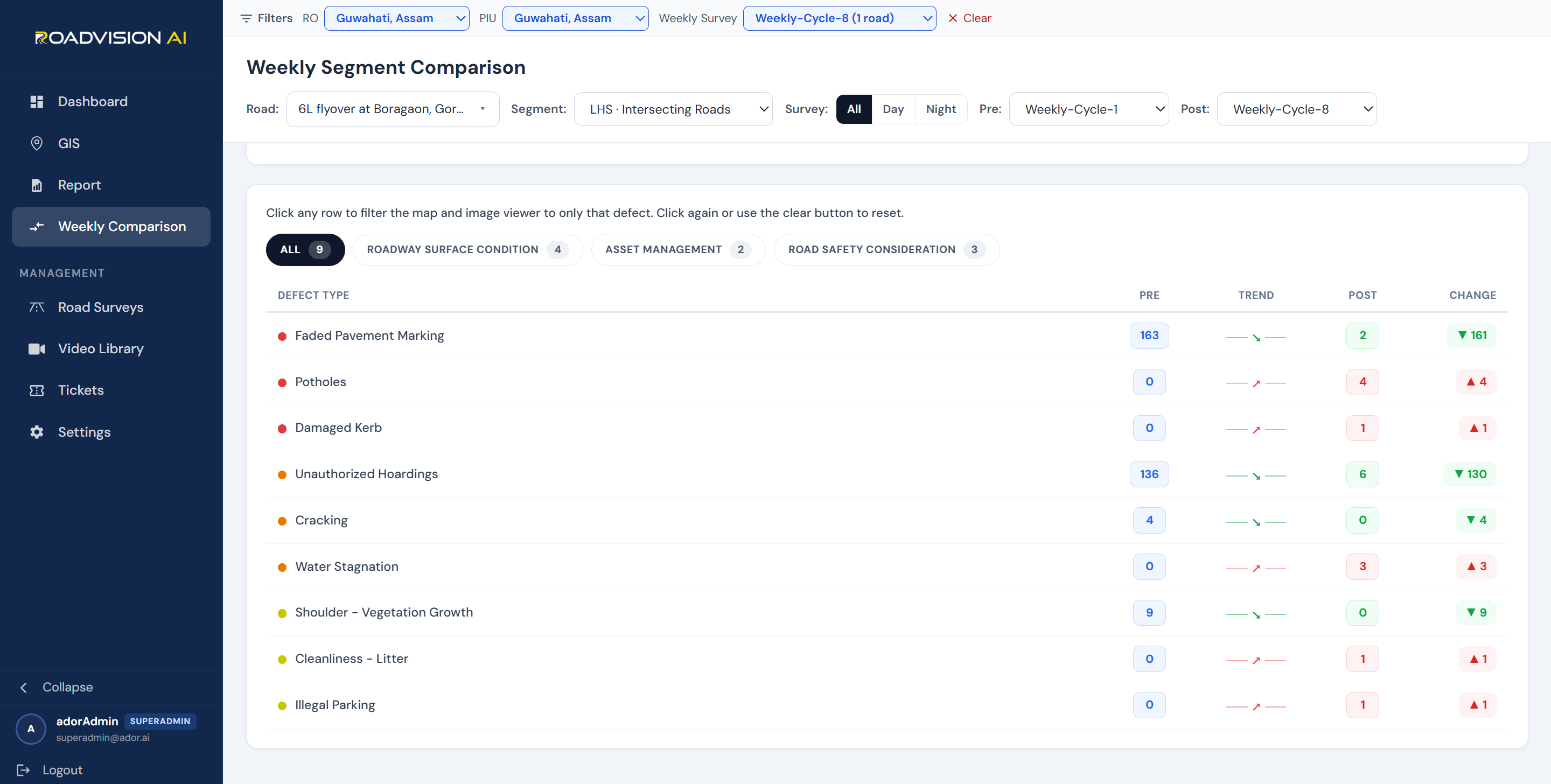
At segment level, the data is more precise still. On the flyover corridor's LHS Intersecting Roads, total findings fell from 312 in Round 1 to 18 in Round 8, with faded pavement marking alone falling from 163 instances to 2. This comparison reflects the same stretch of road, surveyed twice, eight rounds apart, processed through the same detection pipeline on both occasions.
%20-2.jpg)
At segment level, the data is more precise still. On the flyover corridor's LHS Intersecting Roads, total findings fell from 312 in Round 1 to 18 in Round 8, with faded pavement marking alone falling from 163 instances to 2. This comparison reflects the same stretch of road, surveyed twice, eight rounds apart, processed through the same detection pipeline on both occasions.
The flyover corridor is maintained under a concession arrangement, with the maintaining contractor bound to defined service-level obligations under that agreement. NHAI is not required to rely on the contractor's own account of remedial work: each weekly report provides the Regional Office and Project Implementation Unit with a defect ID, chainage and round reference sufficient to raise an Action Taken Report (ATR) request, and the subsequent round's survey re-examines the same coordinates.
This is the enforcement mechanism in practice. A finding is logged, an ATR is requested against it, the contractor undertakes the required action, and the following round's survey either confirms the defect has been resolved or shows that it persists. Verification does not depend on the contractor's representation; it depends on the same chainage point being surveyed under the same method, round after round.
RoadVision AI remains committed to continuous AI-based monitoring of this corridor for the full duration of its two-year mandate with NHAI, and to supporting the contractor compliance that this monitoring enables. The Guwahati Bypass carries the weight of an entire region's connectivity. Ensuring that its maintenance keeps pace with that responsibility, round after round, is central to making this corridor safer for everyone who depends on it.

The Autonomous Road Engineer
AI-powered road condition monitoring, asset management, & infrastructure intelligence helping agencies move from reactive maintenance to predictive road management.


.webp)
.webp)
.webp)