
This is a project-level account from RoadVision AI's weekly highway survey programme for NHAI, covering the Lucknow (Km 11.500) to Sultanpur (Km 138.925) section of NH-56 (now NH-731) in Uttar Pradesh,developed under NHDP Phase-IV on a Hybrid Annuity Mode (HAM) basis. It sets out why the corridor warrants continuous monitoring, how the survey data iscollected and processed, what ten rounds of monitoring have found to date, and how NHAI uses this record against the developer's ongoing maintenance obligations
The Lucknow to Sultanpur section of NH-56 (renumbered NH-731) runs approximately 127.4 km, from Km 11.500 to Km 138.925, through Uttar Pradesh. Its four-laning was approved by the Cabinet Committee on Economic Affairs, chaired by the Prime Minister, under NHDP Phase-IV, on a Hybrid Annuity Mode (HAM) basis, at an estimated cost of ₹2,844.72 crore inclusive of land acquisition, resettlement and rehabilitation, and other pre-construction activities. The project was expected to generate employment potential of approximately 5,19,384 man days during construction, with the explicit objective of reducing travel time and cost for traffic, particularly heavy traffic, on this stretch.
A HAM contract creates a maintenance dynamic distinctfrom a conventional EPC handover: NHAI's annuity payments to the project'sdeveloper,.are linked to the asset continuing to meet defined performance andsafety standards through the contract's operational period, not only at thepoint of construction completion. That structure is what makes an independent,continuously refreshed condition record valuable here it gives NHAI evidenceof whether the standard those annuity payments are made against is actuallybeing held, round after round.
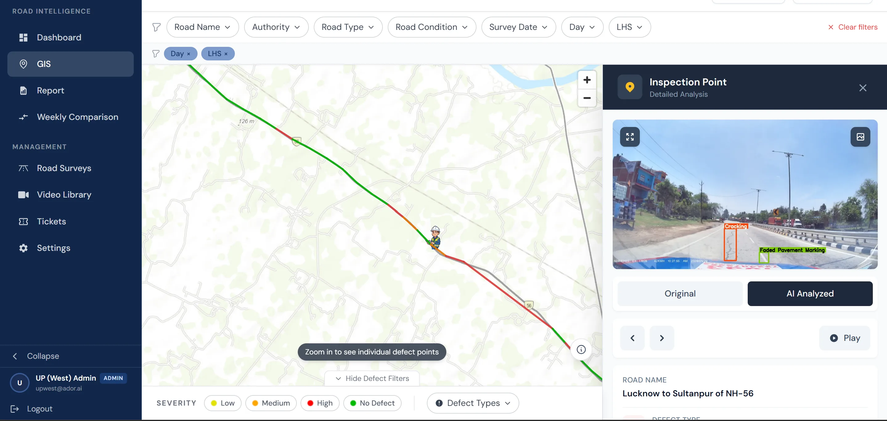
Every finding from every survey round is recorded on alive GIS map spanning the corridor. Each inspection point can be opened to reveal its exact location, the defect type flagged, and the underlying image or video frame, shown in both its original and AI-annotated form. For NHAI's RO West UP and its Lucknow Project Implementation Unit, this allows a summary finding to be traced back to the precise stretch of road and the corresponding photographic evidence.
Figure 1 shows an inspection point on the Lucknow–Sultanpur corridor, flagging cracking and faded pavement marking at its exact position on the road.
The corridor is surveyed by both day and night, and thedistinction is not incidental. Some of the most safety-relevant assets on ahighway lighting, reflective markings, hazard markers can only bemeaningfully assessed once it is actually dark. The most recent round, run atnight, recorded 1,089 non-functional highway lights on this corridor: a defectclass that a daytime-only survey would never surface, however thorough, becausea light that has failed is invisible in daylight.
This is a direct argument for surveying in the sameconditions road users actually experience. A corridor rated safe by day canstill be materially unsafe after dark, and NHAI's oversight of the developer'smaintenance obligations needs to reflect that rather than rely on daylightinspection alone.
The corridor comprises the Main Carriageway, Service Roads and Intersecting Roads, each surveyed independently in both directions six distinct facets of condition data at every chainage point, spread across 127.4 km. Consolidating this consistently, by both day and night, is not achievable through manual inspection at the frequency the corridor requires.
As with any live maintenance contract, the moresignificant challenge is not defect identification but defect verification. Asingle site visit establishes the road's condition on the day, and in thelighting conditions, it is surveyed; it cannot establish whether a repaintedmarking or a restored light remained effective weeks later. Withoutround-on-round comparison, a defect count is a static record. With it, the samedata becomes evidence of whether the developer's maintenance obligations underthe HAM agreement are being met.
Surveys are conducted weekly across the full corridor,covering every road type and direction, by day and by night. Each survey vehicle is fitted with a mounted dashcam that captures continuous footage while recording GPS coordinates at fixed intervals, allowing every frame to be tied to a precise chainage point. Both the raw footage and the AI-processed output are retained for every round, giving NHAI a complete and retrievable survey record.
Each frame is processed against a structured defecttaxonomy covering pavement condition, road markings, signage, lighting,drainage, barriers, encroachment and other roadside assets. Every findinggenerated through this process is recorded with a unique defect ID, precise GPScoordinates and chainage, a severity grade, and a confidence score from thedetection model, ensuring that each entry carries a traceable basis.
Findings are also checked against every prior roundcaptured at the same location. This is what enables round-on-round comparison:a finding from one round can only be assessed against a finding from another ifboth are tied to the same location and classified using the same criteria.
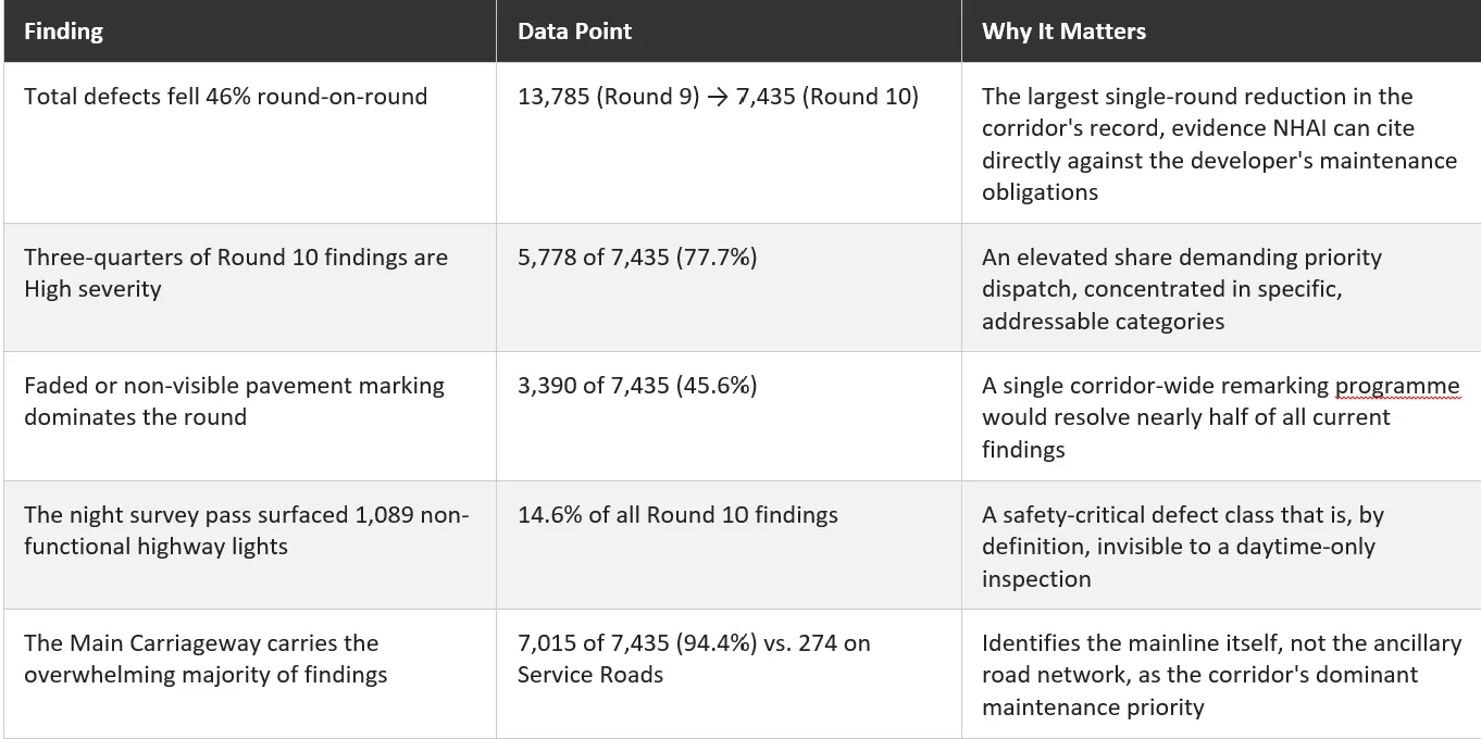
As of Round 10 of the survey programme (Survey IDN/08020/01001/UP_010_110926), RoadVision AI has completed ten weekly rounds onthis corridor. Round 10 recorded 7,435 findings, a 46% reduction from the13,785 findings recorded in Round 9 the largest single-round drop across the corridor's record to date, with the decline arriving after a run-up acrossRounds 6 to 9 that had seen the count climb from 4,820 to 13,785 before thisround's sharp fall.
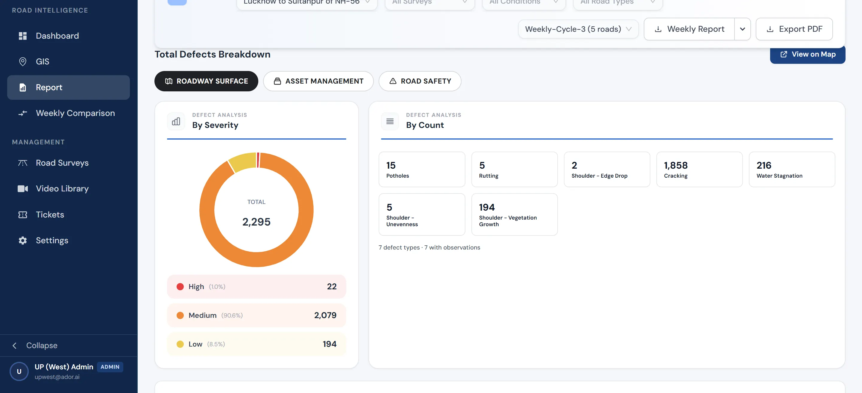
Of Round 10's 7,435 findings, 5,778 (77.7%) were graded High severity a markedly elevated share with faded or non-visible pavement marking alone accounting for 3,390 findings (45.6%), and non-functional highway lighting, surfaced specifically by the night survey pass, accounting for a further 1,089 (14.6%). By road type, the Main Carriageway carried 7,015 of the7,435 findings (94.4%), against 274 on Service Roads and 146 on Intersecting Roads identifying the mainline itself, rather than the ancillary road network, as the corridor's dominant maintenance priority.
The corridor is developed and maintained under a Hybrid Annuity agreement, with the developer., bound todefined performance and safety standards for the duration of the annuity period. NHAI is not required to rely on the developer's own account of remedial work: each weekly report provides RO West UP and the Lucknow PIU with a defect ID, chainage and round reference sufficient to raise an Action Taken Report(ATR) request, and the subsequent round's survey re-examines the same coordinates.
This is the enforcement mechanism in practice. A findingis logged, an ATR is requested against it, the developer undertakes therequired action, and the following round's survey either confirms the defecthas been resolved or shows that it persists. Verification does not depend onthe developer's representation; it depends on the same chainage point beingsurveyed under the same method, round after round, for as long as the annuityperiod runs.
RoadVision AI remains committed to continuous AI-based monitoring of the Lucknow–Sultanpur corridor for the duration of its mandate with NHAI, and to supporting the developer compliance that this monitoring enables. A highway built to reduce travel time and cost for the region's heaviest traffic only delivers on that promise if it is kept to standard, byday and by night, for the life of its annuity period. Ensuring that verification keeps pace with that responsibility, round after round, is centralto making this corridor safer for everyone who depends on it.

The Autonomous Road Engineer
AI-powered road condition monitoring, asset management, & infrastructure intelligence helping agencies move from reactive maintenance to predictive road management.


.webp)
.webp)
.webp)