Post-Flood Road Damage Assessment: How AI Cuts Response Time by 80%
On this page
When a flood recedes, the real work is only beginning. Roads that were passable days earlier may now be washed out, undermined, or buried under debris—and until authorities know exactly where the damage is, emergency services can't move safely, relief supplies can't reach affected communities, and residents can't return home. Traditionally, this assessment process has relied on ground crews physically driving or walking damaged routes, a slow and often dangerous task when roads themselves may be unstable or inaccessible.
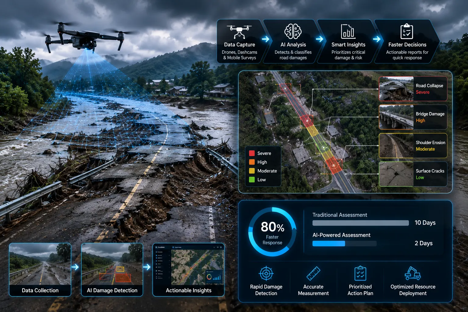
Rapid road damage assessmentpowered by artificial intelligence is transforming this critical first phase of disaster recovery. By combining satellite imagery, aerial drone footage, and machine learning, response teams can now identify damaged road segments within hours instead of days in some documented deployments, cutting assessment time by as much as 80%. In this blog, we'll explore how AI-driven post-disaster road assessment works, the technologies behind it, and why it's becoming an essential tool for emergency management agencies worldwide.
Why Post-Flood Road Assessment Is So Critical and So Difficult
Roads are the arteries of disaster response. Ambulances, fire trucks, relief convoys, and utility repair crews all depend on knowing which routes are safe to travel. Yet flooding creates a uniquely difficult assessment environment:
Widespread, Scattered Damage: Floods rarely affect a single road they can compromise hundreds of kilometers of network simultaneously, including bridges, culverts, and embankments.
Hidden Structural Risk: Floodwater can erode road subgrades and undermine bridge foundations in ways that aren't visible from the surface, creating hazards that look passable but aren't.
Access Limitations: The very roads that need assessment may be the ones blocking access to ground survey teams, creating a chicken-and-egg problem.
Time Pressure: Every hour of delay in identifying safe routes extends the time before emergency services, relief supplies, and displaced residents can move freely.
Safety Risks for Survey Crews: Sending personnel to inspect roads that may still be unstable, flooded, or affected by continuing weather puts assessment teams themselves at risk.
These factors combine to make traditional, ground-based assessment both slow and hazardous exactly the conditions where AI-powered remote assessment offers the greatest advantage.
How AI-Powered Rapid Road Damage Assessment Works
1. Satellite Imagery Acquisition
Immediately following a flood event, satellite imaging providers can capture high-resolution imagery of affected regions, often within hours of a storm passing, depending on satellite tasking availability and cloud cover. This provides a broad, top-down view of the affected road network before ground teams can even mobilize.
2. Aerial Drone Supplementation
Where satellite resolution or cloud cover is insufficient, drones equipped with high-resolution cameras and LiDAR can be rapidly deployed to capture detailed imagery of specific road segments, bridges, and critical infrastructure points, filling in gaps that satellites can't resolve.
3. Pre- and Post-Event Image Comparison
AI models compare newly captured post-flood imagery against pre-disaster baseline imagery of the same road network. This before-and-after comparison is central to rapid assessment—rather than analyzing road conditions from scratch, the system focuses specifically on detecting change: washed-out sections, new debris fields, submerged roadways, or collapsed structures.
4. Computer Vision Damage Classification
Trained computer vision models identify and classify specific types of damage visible in the imagery, including:
Road segments fully washed away or eroded
Sections still submerged or flooded
Landslide or debris blockage
Bridge or culvert structural damage
Partial surface damage versus complete impassability
5. Severity Scoring and Prioritization
Detected damage is scored by severity and cross-referenced with contextual data proximity to hospitals, shelters, or evacuation routes—to generate a prioritized list of road segments requiring the most urgent attention or ground verification.
6. Rapid Mapping and Dashboard Output
Results are compiled into a geospatial dashboard, typically within hours of imagery capture, giving emergency operations centers a near-real-time map of road accessibility across the affected region. This map can be continuously updated as new imagery becomes available.
7. Integration with Emergency Response Coordination
The most effective systems feed directly into emergency management platforms, allowing responders to route ambulances, relief convoys, and repair crews around confirmed impassable segments without waiting for manual ground reports.
Why AI Assessment Can Cut Response Time So Dramatically
Traditional post-flood road assessment typically involves deploying ground teams sequentially across a damaged region, physically verifying each route before it can be marked safe or unsafe a process that can take days or even weeks across a large disaster zone. AI-powered satellite and aerial assessment compresses this timeline in several ways:
Simultaneous, Wide-Area Coverage: A single satellite pass or coordinated drone deployment can capture data across an entire affected region at once, rather than assessing road segments one at a time.
Elimination of Access Barriers: Remote imagery doesn't require physical access to a road, allowing assessment of segments that are still cut off from ground teams.
Automated Analysis: AI models can process thousands of image segments in the time it would take a single analyst to review a handful manually, removing a major analytical bottleneck.
Continuous Re-Assessment: As conditions change floodwaters receding, additional debris clearing new imagery can be captured and reprocessed quickly, keeping the damage map current without repeated full ground surveys.
Some emergency management deployments using this combined satellite-AI approach have reported cutting overall initial road assessment time by as much as 80% compared to purely ground-based survey methods turning a process that once took days into one that can begin producing actionable results within hours.
Key Technologies Behind Satellite and AI Road Damage Assessment
High-Resolution Earth Observation Satellites: Provide the wide-area imagery foundation for rapid, large-scale damage detection.
Synthetic Aperture Radar (SAR): Particularly valuable in flood scenarios because SAR can penetrate cloud cover and capture imagery even during ongoing storms, unlike optical satellite imagery.
Convolutional Neural Networks (CNNs): Power the image classification models that detect and categorize road damage types from satellite and aerial imagery.
Change Detection Algorithms: Specialized AI techniques that isolate meaningful differences between pre- and post-event imagery while filtering out irrelevant variations like lighting or seasonal changes.
GIS Integration: Ensures detected damage is accurately mapped and cross-referenced with existing road network and infrastructure data.
Cloud-Based Processing Pipelines: Enable rapid ingestion and analysis of large imagery datasets shortly after capture, critical for meeting tight disaster-response timelines.
Benefits of AI-Powered Post-Disaster Road Assessment
For Emergency Management Agencies
Faster Situational Awareness: Decision-makers gain a comprehensive view of road network status within hours rather than days.
Safer Deployment of Ground Crews: Remote assessment helps prioritize where physical verification is truly necessary, reducing unnecessary exposure to hazardous conditions.
More Effective Resource Allocation: Prioritized damage data helps direct limited repair crews and equipment to the most critical routes first.
For First Responders and Relief Organizations
Safer, Faster Routing: Ambulances and relief convoys can be directed around confirmed impassable roads without delay.
Improved Coordination: Shared, continuously updated damage maps improve coordination across multiple responding agencies and organizations.
For Affected Communities
Faster Restoration of Access: Quicker identification and repair of critical routes means faster restoration of access to essential services, supplies, and support.
Reduced Uncertainty: Clear, data-driven road status information helps residents make safer decisions about evacuation or return.
Real-World Applications
Hurricane and Tropical Storm Response: Coastal regions prone to hurricane-driven flooding increasingly use satellite-based rapid assessment to evaluate road networks immediately after storms pass, well before ground crews can safely mobilize.
Riverine and Flash Flood Events: Inland flooding from heavy rainfall or river overflow benefits from drone-supplemented assessment, particularly in areas where satellite revisit timing doesn't align with the event.
Cross-Border Disaster Coordination: International relief organizations use satellite-derived road damage data to coordinate logistics and resource allocation across affected regions, independent of local ground infrastructure availability.
Insurance and Infrastructure Damage Claims: Beyond emergency response, rapid damage assessment data is increasingly used to support infrastructure damage documentation for insurance and government disaster relief funding processes.
Challenges and Limitations
Despite its transformative potential, AI-powered post-disaster road assessment faces some real-world constraints:
Satellite Availability and Timing: Optical satellite imagery can be delayed by cloud cover during active storms, though SAR technology helps mitigate this limitation.
Resolution Constraints: Satellite imagery resolution may not always be sufficient to detect smaller-scale damage, such as minor surface cracking or partial subgrade erosion, requiring drone or ground follow-up for detailed assessment.
Model Training Data Gaps: AI models require diverse training data covering various flood types, road materials, and regional infrastructure styles to maintain accuracy across different geographies.
Connectivity for Data Transmission: Processing and disseminating results quickly requires reliable data connectivity, which can itself be disrupted in disaster-affected regions.
Verification Requirements: While AI assessment dramatically accelerates initial evaluation, some level of ground verification is typically still required before roads are officially reopened to traffic, particularly for structural concerns like bridge integrity.
The Future of Rapid Road Damage Assessment
As satellite constellations expand and AI models improve, post-disaster road assessment capabilities are expected to become faster, more accurate, and more widely accessible. Emerging trends include:
Increased Satellite Revisit Frequency: Growing constellations of small satellites are reducing the time between imagery captures, enabling near-continuous monitoring during extended flood events.
Automated Drone Swarms: Coordinated drone fleets may soon be deployable immediately following a disaster to supplement satellite data with high-resolution, targeted imagery of critical infrastructure.
Predictive Pre-Positioning: Combining weather forecasting with infrastructure vulnerability data may allow agencies to pre-position assessment resources ahead of anticipated flood events, further compressing response timelines.
Integration with Broader Disaster Management Platforms: Rapid road assessment data is increasingly being integrated into comprehensive disaster response platforms that coordinate road, utility, and structural damage assessment together.
Global Data-Sharing Standards: International cooperation on satellite data sharing and standardized damage classification could improve response coordination for cross-border disaster events.
Conclusion
Post-flood road damage assessment has long been one of the slowest and most dangerous phases of disaster recovery, but AI-powered satellite and aerial analysis is fundamentally changing that reality. By combining wide-area satellite coverage, targeted drone imagery, and AI-driven change detection, emergency management agencies can now generate actionable road damage assessments within hours instead of days—helping route emergency responders more safely, direct relief resources more effectively, and restore community access faster than ever before. As satellite technology and AI models continue to advance, rapid road damage assessment is set to become an indispensable tool in disaster response strategies worldwide.
Frequently Asked Questions (FAQs)
1. What is rapid road damage assessment?
Rapid road damage assessment is the process of using AI, satellite imagery, and aerial data to quickly identify and evaluate road damage after a disaster, significantly reducing the time needed compared to traditional ground-based surveys.
2. How does satellite imagery help assess post-flood road damage?
Satellite imagery provides wide-area, top-down views of affected regions shortly after a flood, allowing AI models to compare pre- and post-event images and detect washed-out roads, debris, and structural damage across large areas simultaneously.
3. How much time can AI save in post-disaster road assessment?
While results vary by deployment and disaster scale, some organizations using combined satellite and AI-based assessment have reported cutting initial road damage assessment time by as much as 80% compared to purely manual, ground-based methods.
4. Can satellite imagery see through clouds during a storm?
Optical satellite imagery can be obstructed by cloud cover, but Synthetic Aperture Radar (SAR) technology can penetrate clouds and capture usable imagery even during active storms, making it valuable for flood assessment.
5. Does AI road damage assessment replace ground verification?
Not entirely. AI-powered remote assessment dramatically accelerates initial evaluation and prioritization, but ground verification is typically still required before officially reopening roads, especially for structural concerns like bridge safety.




.webp)
.webp)
.webp)