There is a piece of road safety infrastructure so ubiquitous, so embedded into the visual landscape of every road and highway, that most drivers never consciously register it until it is gone. Lane lines. Edge lines. Stop bars. Pedestrian crossings. Arrow markings. Cycle lane delineators. These painted or thermoplastic lines are the silent guidance system of every road network the visual language through which roads communicate with drivers, cyclists, and pedestrians twenty-four hours a day.
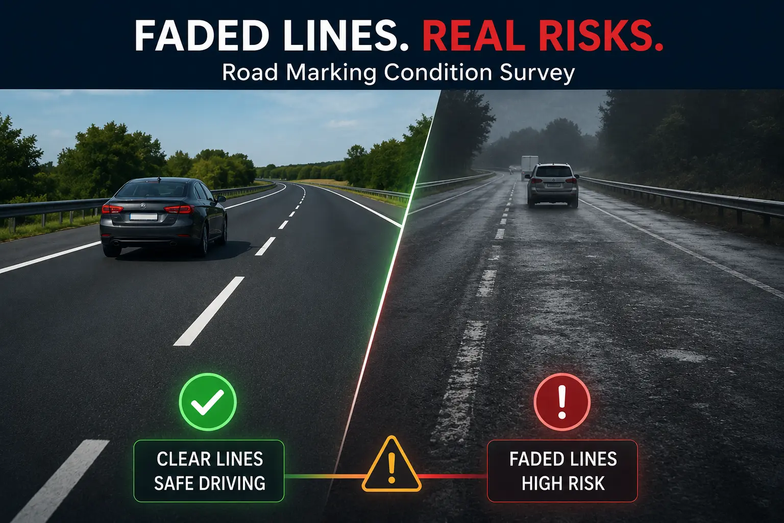
When they are clear, bright, and retroreflective, they do their job invisibly. Drivers stay in lanes. Pedestrians cross safely. Cyclists know where they belong. Intersection behavior is orderly.
When they fade and they always fade the consequences are far less invisible.
Faded road markings are a documented contributor to lane departure crashes, pedestrian fatality events, wrong-way driving incidents, and intersection collisions. The UK Department for Transport has identified road marking deterioration as a factor in thousands of serious injury crashes annually. Transport Canada's road safety data consistently shows elevated crash rates on road sections with below-standard marking visibility, particularly at night and in wet conditions when retroreflectivity is the primary driver of line visibility.
Yet despite this well-established relationship between marking condition and road safety, road marking condition survey remains one of the most neglected elements of road asset management. Markings are painted, their condition is rarely systematically monitored, and deterioration is typically identified only after a marking has failed completely or after an incident has occurred.
RoadVision AI is changing that. Our AI-powered road marking condition survey platform gives road authorities the tools to monitor marking condition continuously, identify deterioration proactively, and prioritize remarking programs with data rather than guesswork keeping the lines visible, and keeping drivers safe.
Understanding why road marking condition matters requires understanding how markings work and why they fail. Road markings are not simply paint on pavement they are engineered retroreflective systems designed to return light from vehicle headlamps directly back toward the driver's eyes, making them visible at night and in adverse weather conditions far beyond what simple painted colour could achieve.
The retroreflectivity of a road marking is primarily created by glass microspheres tiny glass beads embedded in or applied to the surface of the marking material. These beads act as optical retroreflectors, bouncing incoming headlamp light back to its source. The retroreflective performance of a marking measured in millicandelas per square metre per lux (mcd/m²/lux) determines how bright the marking appears to a driver at night from a standard viewing angle.
New road markings typically achieve retroreflectivity values of 200 to 400 mcd/m²/lux or higher, depending on the marking type and material. Transport Canada and the Transportation Association of Canada (TAC) specify minimum retroreflectivity thresholds typically 100 to 150 mcd/m²/lux for lane lines on high-speed roads below which a marking is considered functionally inadequate for night driving safety.
Road markings deteriorate through multiple mechanisms:
Traffic Wear Vehicle tyres passing repeatedly over painted markings erode the surface material and dislodge the glass microspheres that provide retroreflectivity. High-traffic lanes particularly wheel tracks deteriorate far faster than the same marking in lower-traffic positions. A wheel-track section of a lane line may lose 70% of its retroreflectivity within 18 months on a high-volume highway while the adjacent median line remains within specification.
Winter Maintenance Operations Snow plough blades exert direct mechanical abrasion on road marking surfaces, removing material with each pass. De-icing salt and sand applications accelerate chemical deterioration of marking binders and further abrade microsphere layers. In Canadian climates where a road surface may be ploughed dozens of times per winter season, winter operations alone can reduce marking service life by 30 to 50%.
Ultraviolet DegradationSustained UV exposure causes the binder materials in painted and thermoplastic markings to become brittle, crack, and separate from the pavement surface a process called chalking. UV degradation is most severe on road surfaces with high solar exposure and is particularly problematic for white markings, which absorb less heat but are more susceptible to UV-induced colour shift.
Thermal Cycling The freeze-thaw cycles that are endemic to Canadian climates cause pavement surfaces to expand and contract seasonally, stressing the bond between marking material and road surface and leading to edge lifting, cracking, and eventual delamination of marking material.
Water and Contamination Water infiltration beneath marking material, combined with oil contamination from vehicle traffic, degrades adhesion between the marking and pavement surface leading to peeling, blistering, and progressive delamination that dramatically accelerates visible deterioration.
The cumulative effect of these mechanisms means that road markings in active service degrade continuously and non-linearly with deterioration accelerating sharply once retroreflectivity drops below a threshold level and structural failure of the marking material begins.
Given the safety significance of road marking condition, one might expect systematic, data-driven monitoring programs to be standard practice across all road authorities. In reality, the gap between best practice and common practice is stark.
Visual inspection is subjective and unreliable. The most common approach to road marking condition assessment remains the drive-by visual inspection a staff member driving a route and rating marking condition on a subjective scale. This approach produces inconsistent results between inspectors, is completely ineffective at night or in wet conditions, captures no retroreflectivity data, and cannot detect the early stages of glass bead depletion that precede visible deterioration.
Retroreflectometer surveys are accurate but impractical at scale. Handheld retroreflectometers devices that measure the retroreflective luminance of a marking sample — provide accurate, standardized data but require an operator to stop, exit the vehicle, position the device on the road surface, and take a reading. Surveying a single kilometre of road this way takes hours. Network-scale assessment is practically impossible.
Mobile retroreflectometer surveys are expensive. Vehicle-mounted retroreflectometer systems that can measure marking retroreflectivity at low vehicle speeds (30–50 km/h) exist but are expensive specialist equipment requiring dedicated survey vehicles, trained operators, and significant survey time. Most road authorities conduct full retroreflectivity surveys on major roads only every three to five years far too infrequently to catch marking deterioration before it becomes a safety issue.
Surveying schedules miss seasonal dynamics. Road marking condition in Canadian climates changes dramatically between summer survey conditions and the post-winter state after months of snow ploughing and de-icing operations. An annual summer survey produces no information about the condition that actually prevailed during the highest-risk winter driving period.
There is no proactive trigger for remarking. Without continuous condition monitoring, remarking programs are driven by inspection cycles, budget availability, and complaint response — not by actual marking condition. The result is a system where some markings are replaced well before the end of their service life while others remain in service far beyond their safe useful life.
RoadVision AI's AI-powered road marking condition survey platform solves every one of these limitations.
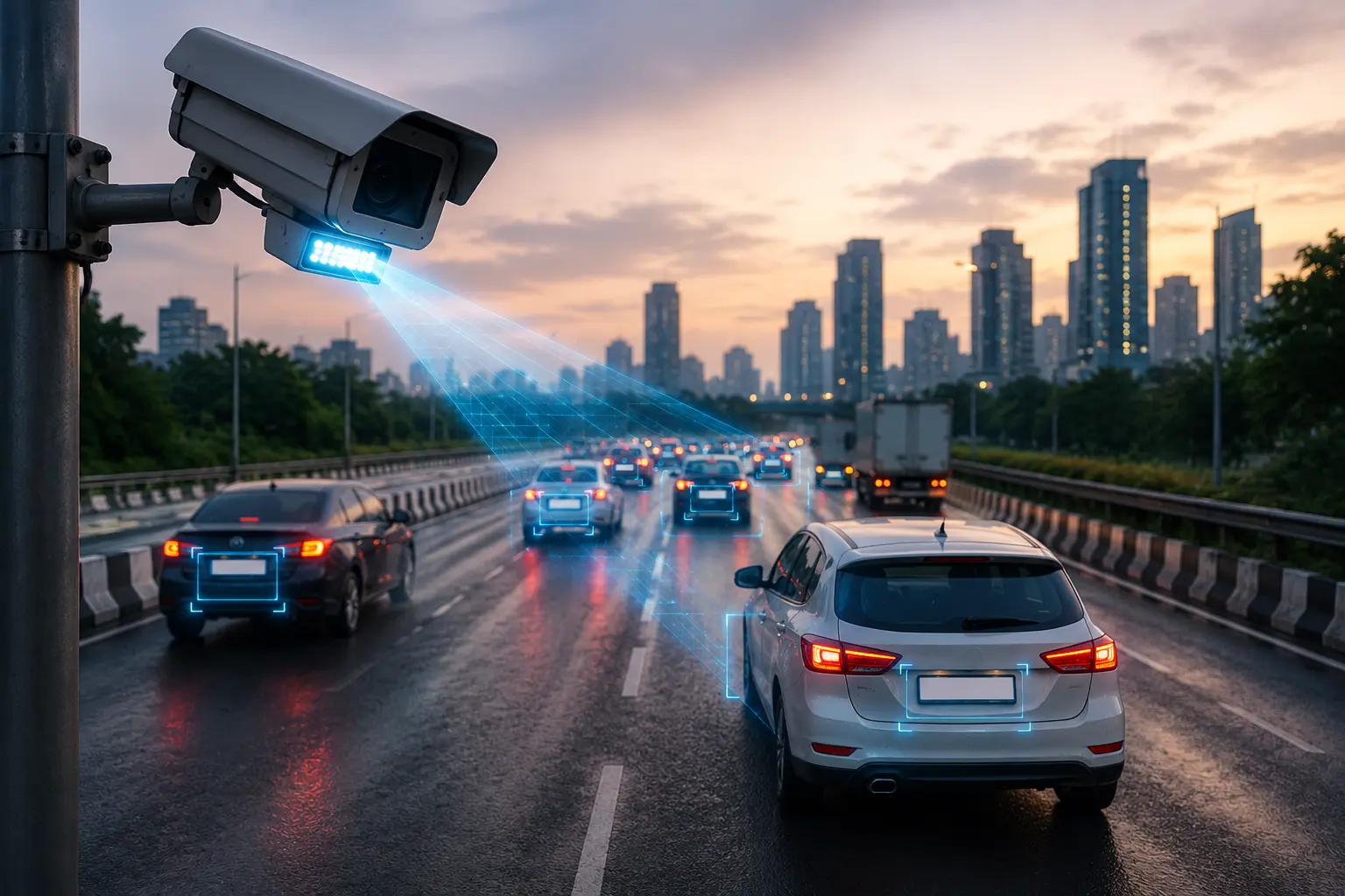
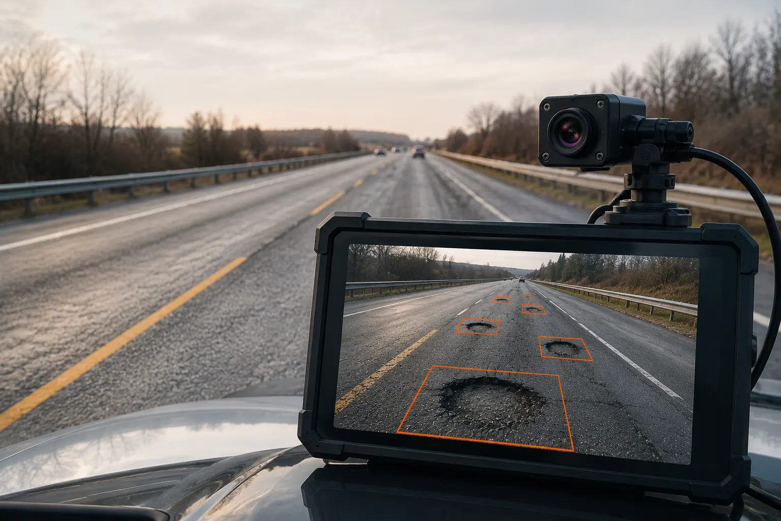
RoadVision AI's road marking survey system uses the same vehicle-mounted sensor platform as our pavement inspection solution — integrating high-resolution cameras with forward, downward, and oblique imaging angles, LiDAR surface scanners, and calibrated luminance sensors into a compact, all-weather unit mountable on standard maintenance fleet vehicles.
As equipped vehicles travel their normal operational routes day or night, summer or winter the system continuously captures imagery and measurement data across every metre of road surface, including all visible pavement markings. Night surveys, conducted with controlled illumination geometry, capture retroreflectivity proxy data that correlates with calibrated retroreflectometer readings to within acceptable engineering margins.
This continuous, embedded approach means road marking condition is assessed on the same frequency as vehicle operations weekly or more rather than annually or biannually.
RoadVision AI's computer vision engine automatically detects and classifies every type of road marking present in the survey imagery:
For each detected marking, the system assesses:
Visibility and contrast — measuring the luminance contrast between the marking and the surrounding pavement surface, a key indicator of daytime and wet-weather visibility.
Retroreflectivity proxy — using calibrated night-imaging data to estimate the retroreflective performance of each marking section, flagging segments below regulatory threshold values.
Continuity and completeness — detecting gaps, breaks, and missing marking sections that may result from previous wear, patching, or maintenance operations.
Edge integrity — identifying edge fraying, cracking, and delamination that indicate impending structural failure of the marking material.
Coverage loss — calculating the percentage of the nominal marking area that retains functional material, distinguishing between partially worn markings that remain within specification and those that have lost sufficient material to require immediate remarking.
Every marking assessment is geo-referenced and plotted on RoadVision AI's live GIS dashboard, giving road asset managers a complete, continuously updated map of marking condition across their entire network. Markings are color-coded by condition state from green (within specification) through amber (approaching threshold) to red (below minimum standard, immediate action required).
The dashboard enables filtering by marking type, road classification, jurisdiction, or geographic area, and generates automatic priority work lists ranked by safety criticality combining condition score, traffic volume on the affected road, and the marking's functional role in the road safety system.
RoadVision AI's predictive module models the remaining service life of each marking section based on current condition, historical deterioration rate for that road type and traffic loading, seasonal maintenance activity data, and material type. This forward-looking projection enables road authorities to plan remarking programs on an optimized preventive cycle rather than a reactive emergency basis.
The platform generates rolling 12-month remarking programs automatically, grouping work by geographic corridor and marking type to minimize mobilization costs and traffic disruption and re-optimizing dynamically as new survey data is incorporated.
The connection between road marking condition and road safety outcomes is not a hypothesis it is extensively documented in road safety research across multiple countries and road authority jurisdictions.
Research published by the Transportation Research Board consistently shows that deteriorated pavement markings are associated with elevated rates of lane departure crashes the single deadliest crash type on rural highways. Lane departure crashes account for approximately 40% of all road fatalities in Canada and disproportionately occur at night, in wet conditions, and on roads where marking retroreflectivity has fallen below functional thresholds.
Studies examining the relationship between marking retroreflectivity and crash rates have found statistically significant increases in crash frequency as retroreflectivity drops below 100 mcd/m²/lux the common minimum threshold specified in North American marking standards. Roads with markings below this threshold have been shown to experience night-time crash rates 25 to 45% higher than comparable roads with markings within specification.
For pedestrian crossings specifically, the safety impact of marking condition is acute. High-visibility crosswalk markings ladder-pattern crossings with high retroreflectivity have been shown to reduce pedestrian crash risk by 40 to 70% compared to faded or non-existent markings. As crosswalk markings deteriorate below visibility thresholds, that protective effect erodes directly.
The implication is straightforward: every day a road marking operates below minimum retroreflectivity standards represents an elevated crash risk that road authorities have both a safety obligation and a legal duty to address.
Provincial Highway Networks High-speed rural highways carry the highest lane-departure crash risk and are where marking retroreflectivity plays its most critical role. RoadVision AI enables provincial highway authorities to maintain continuous condition monitoring across their full network, ensuring that no high-speed corridor operates with below-threshold markings during the high-risk winter and early spring periods.
Urban Arterial Roads Urban road networks carry high volumes of vulnerable road users pedestrians, cyclists, and motorcyclists for whom road marking condition is particularly critical. Intersection markings, crosswalk delineations, and cycle lane markings in urban environments deteriorate faster due to high traffic loading but are often assessed less systematically than provincial highway markings.
School Zones and Pedestrian Areas Crosswalk markings and school zone delineations in areas with high pedestrian activity particularly child pedestrians demand the highest marking standards and the most frequent condition monitoring. RoadVision AI enables road authorities to establish priority monitoring for these high-sensitivity locations and ensure remarking is triggered well before safety thresholds are approached.
Airport Runways and Taxiways Aviation pavement marking standards are among the most stringent in the world, with Transport Canada and NAV CANADA specifying tight retroreflectivity and contrast requirements for runway threshold markings, centreline markings, and taxiway guidance systems. RoadVision AI's precision measurement capability meets the accuracy requirements for airfield marking condition assessment.
Bicycle Infrastructure Dedicated cycle lane markings, sharrows, and intersection bicycle boxes are increasingly important components of urban road safety infrastructure. These markings are subject to the same deterioration mechanisms as vehicle lane markings but are often managed with less systematic inspection despite being critical safety information for the most vulnerable road users.
Road marking programs represent a significant annual expenditure for road authorities at every level provincial, municipal, and federal. Optimizing that expenditure through data-driven condition monitoring and proactive remarking scheduling delivers measurable financial benefits.
Extended marking service life. Preventive application of additional microsphere layers or thin overlay treatments at the point where retroreflectivity is declining but before structural failure occurs can extend marking service life by 30 to 50% compared to a reactive replace-when-failed approach.
Reduced emergency remarking costs. Emergency remarking operations mobilizing a line-marking crew to a single location for an urgent safety repair carry mobilization costs that can exceed the cost of the remarking work itself. Network-optimized preventive remarking programs batch work by corridor and type, dramatically reducing unit costs.
Crash cost avoidance. The economic cost of a single serious injury road crash including medical costs, productivity loss, emergency response, and infrastructure damage typically exceeds $500,000 in Transport Canada's standard road safety economic analysis framework. A single prevented serious crash generates cost savings that exceed the annual cost of a comprehensive road marking monitoring program many times over.
Liability risk reduction. Road authorities have a documented duty of care to maintain road markings in a safe condition. Systematic condition monitoring creates an auditable record of inspection and maintenance activity that is essential to mounting an effective legal defence when marking condition is alleged as a contributing factor in crash litigation.
Road marking condition assessment is a specialized discipline that sits at the intersection of road safety, asset management, materials science, and computer vision. RoadVision AI has invested in building the domain-specific models, calibrated measurement methodologies, and Canadian-climate-validated hardware that this application demands.
Our marking detection models are trained on Canadian road marking datasets encompassing all standard provincial marking types, thermoplastic and painted materials, new and severely deteriorated conditions, and all seasonal imagery conditions from full summer sun to post-winter salt-contaminated surfaces. The result is a system that performs where generic road inspection tools consistently fail in the grey zones of partial deterioration where the most important safety decisions are made.
We integrate road marking condition data directly with our pavement inspection and ANPR platforms, giving road authorities a single, unified view of their road network asset condition surface, structure, and safety markings in one operational platform.
Road markings are the most frequently interacted-with road safety infrastructure on any network consulted by every driver, every trip, in every condition. When they perform their function, they are invisible contributors to orderly, safe road use. When they fail, the consequences range from confusion and near-misses to serious injury and fatal crashes.
The failure of road authorities to systematically monitor and proactively manage road marking condition is not a deliberate choice it is a consequence of inspection methods that have simply never been capable of delivering network-scale condition data at the frequency and accuracy that safety management demands.
RoadVision AI's road marking condition survey platform changes that fundamental capability constraint. By embedding AI-powered marking assessment into the routine operations of road maintenance fleets, road authorities gain continuous, accurate, GIS-mapped visibility into the condition of every line on their network and the predictive tools to ensure those lines never fall below the standard that keeps drivers, cyclists, and pedestrians safe.
Because on a dark, wet road at 100 km/h, the difference between a visible lane line and a faded one is the difference between a safe journey home and a lane departure that changes everything.
Ready to take control of your road marking asset condition? Contact RoadVision AI today to arrange a demonstration or discuss a network condition baseline survey for your jurisdiction.
Retroreflectivity is the property of a road marking that causes it to reflect vehicle headlamp light back toward the driver's eyes, making the marking visible at night and in wet conditions. It is measured in millicandelas per square metre per lux (mcd/m²/lux). When retroreflectivity falls below minimum thresholds typically 100 to 150 mcd/m²/lux for lane lines on high-speed roads markings become effectively invisible in night driving conditions, dramatically increasing lane departure crash risk.
Transport Canada and TAC guidelines recommend annual retroreflectivity surveys as a minimum for high-volume provincial highways, with more frequent surveys on roads with high-risk marking locations such as complex intersections and pedestrian crossings. RoadVision AI's continuous monitoring approach enables survey frequency to be matched to actual deterioration rates with high-traffic, high-risk locations assessed as frequently as weekly.
RoadVision AI's mobile survey system captures retroreflectivity proxy data at operational vehicle speeds during night survey runs, using calibrated illumination geometry and luminance sensors. This data correlates with ground-truth retroreflectometer readings to within engineering tolerance levels for network-scale management purposes. For locations requiring certified retroreflectivity measurements for regulatory compliance, the platform identifies priority locations for targeted retroreflectometer verification, minimizing the extent of labour-intensive static measurement required.
The platform assesses all standard road marking types: longitudinal markings including lane lines, centrelines, edge lines and no-passing zones; transverse markings including stop bars, yield lines, and pedestrian crossings; symbol and word markings including directional arrows, speed legends, and cycle markings; and raised pavement marker condition. Each marking type is assessed against its applicable standard and reported separately in the condition inventory.
RoadVision AI's detection models include training data from winter and early spring road surfaces, maintaining reliable marking detection on partially salt-contaminated and debris-covered road surfaces. Heavily snow-covered markings that are completely obscured are logged as unassessable for the survey pass, with the system automatically flagging these locations for re-survey when conditions improve. Winter condition surveys are particularly valuable for identifying markings that have suffered winter maintenance damage before the spring remarking season.

The Autonomous Road Engineer
AI that is transforming road infrastructure, from reactive to predictive.